


Drought Management and Precise Spot Spraying with DJI Agras T50 and RTK
Drought management is not simply about spraying less water. It starts with monitoring, scouting, irrigation decisions, soil management and identifying where a legal crop-protection treatment is actually needed. T50 and RTK can help execute repeatable spot-spray zones after those decisions are made.
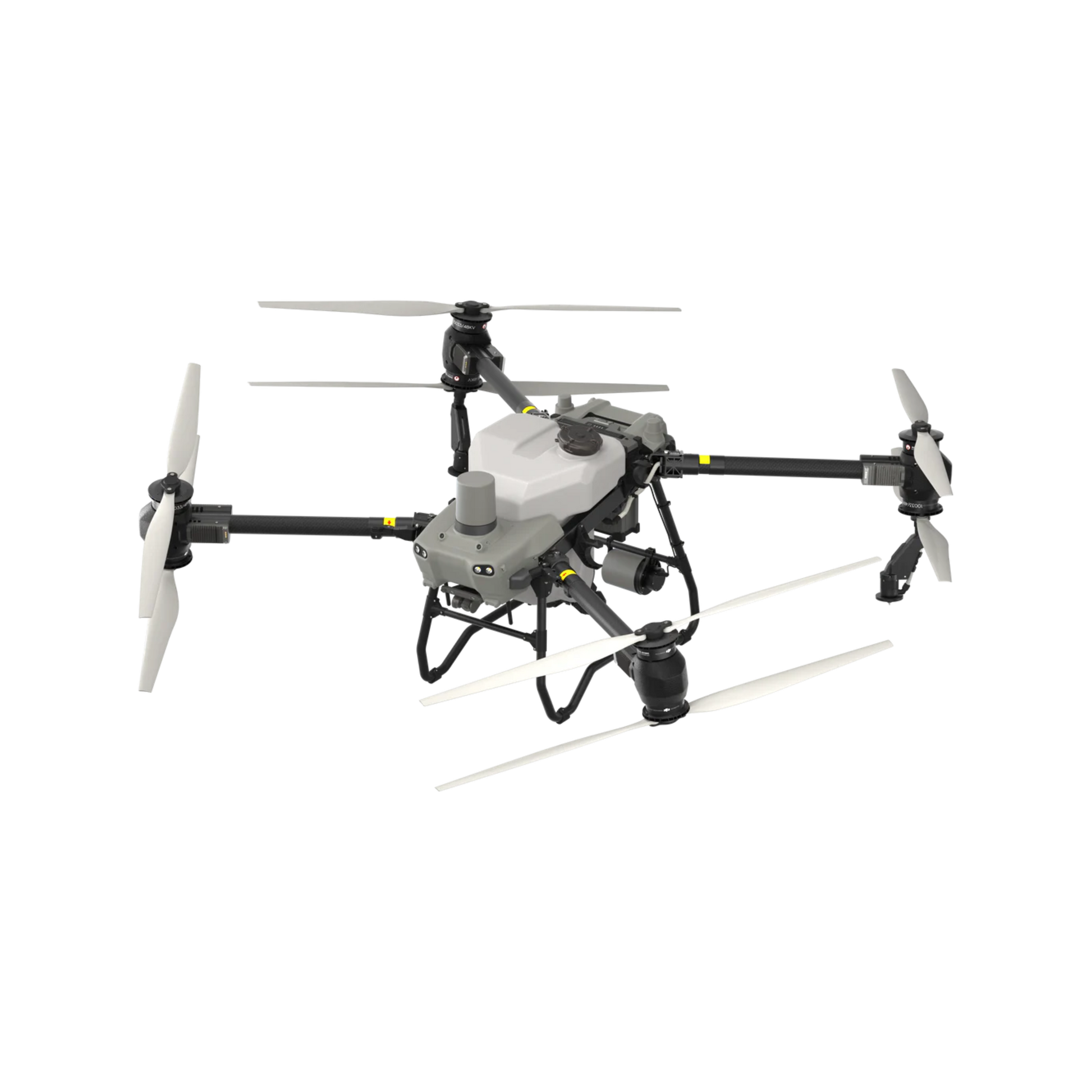
T50 combines a 40 L spray system, RTK positioning, field and orchard surveying, radar, binocular vision and automatic route execution.
T50 supports targeted crop protection. It does not replace irrigation.
A drought-stressed crop may need water, a change in management, or no pesticide application at all. T50 becomes relevant only when scouting confirms a treatable pest, disease, weed or nutrient-related zone and the selected product permits aerial application.
A 40 L application tank cannot solve a field water deficit.
Irrigation decisions require soil moisture, crop stage, water availability, system capacity and regulatory review. Do not present an agricultural spray drone as a watering replacement.
RTK improves repeatability and route consistency.
DJI specifies approximately plus or minus 10 cm horizontal and vertical hovering accuracy with strong GNSS and RTK enabled. That helps the aircraft repeat mapped paths and zone boundaries.
It limits treatment to confirmed zones.
Spot spraying can reduce the total area treated when the problem is genuinely localized. It does not authorize a lower labelled rate, reduced minimum aerial volume or weaker buffer zone.
Use several signals before drawing a treatment zone.
A low vegetation index or dry-looking patch can be caused by water stress, soil variation, compaction, drainage, insects, disease, nutrient deficiency, herbicide injury, emergence problems or shadow. A map is a scouting priority, not a final diagnosis.
Use the Canadian Drought Monitor for regional severity and change, then confirm the actual farm.
Review soil moisture, rooting depth, texture, compaction, drainage and irrigation records.
Check crop stage, symptoms, pest distribution, disease, weeds and recent management history.
Use RGB or multispectral information to prioritize zones, then ground-truth before prescribing.
A reliable spot-spray prescription has eight stages.
The workflow separates drought observation from pesticide application. T50 enters only after the problem, product, zone and legal pathway are verified.
Observe
Review weather, crop stage, irrigation records, soil conditions and regional drought information.
Map
Capture field boundaries and crop variation with T50 surveying or an optional RGB and multispectral platform.
Analyze
Compare indices and imagery with soil, crop history, drainage, topography and recent management.
Ground-truth
Walk or sample the zones to determine whether the signal is drought, pest, disease, weeds or another cause.
Decide
Select irrigation, scouting, no action, cultural management or a legal crop-protection treatment.
Apply
Load only confirmed zones, follow the aerial label and execute the RTK route with calibrated settings.
Verify
Review coverage, route completion, untreated buffers, misses, overlaps and actual field response.
Record and improve
Save map version, product, rate, volume, settings, weather, crew, result and corrective actions.
Centimetre-level positioning is valuable only when the map is correct.
RTK can help T50 repeat routes, hold boundaries and reduce inconsistent passes. It cannot fix a false drought diagnosis, an incorrect polygon, a poor swath calibration or an illegal pesticide use.


| RTK contribution | What it can improve | What it cannot guarantee |
|---|---|---|
| Boundary repeatability | More consistent return to mapped treatment zones | That the zone diagnosis or property boundary is correct |
| Pass consistency | More repeatable route spacing and location | Uniform deposition without correct swath and flow calibration |
| Prescription execution | Following accepted polygons or variable-rate zones | Automatic agronomic validity or legal product selection |
| Record quality | More defensible route and treatment-zone documentation | Compliance when label, licence, PPE or crew rules are not followed |
Reduce treated area, not the required treatment standard.
The economic and environmental opportunity comes from avoiding unnecessary acres. Within each treated polygon, the application still follows the registered aerial rate, minimum volume, droplet requirement and buffer zone.
Localized, verified and legally treatable.
- Problem occupies defined patches rather than the entire field.
- Ground scouting confirms the mapped signal.
- The product permits aerial application for the crop and target.
- Zone edges can be kept clear of sensitive areas and buffers.
- Refill and battery logistics remain practical at the required volume.
Diffuse stress, uncertain diagnosis or high-volume need.
- Drought stress is uniform across most of the field.
- The mapped signal has not been ground-truthed.
- The product does not permit aerial application.
- The label volume creates an impractical refill burden.
- Dense canopy coverage cannot be demonstrated.


Data can prioritize scouting and support prescription maps.
T50 can survey fields and orchards for route creation. Mavic 3M adds RGB and multispectral data. DJI SmartFarm can reconstruct field, orchard and multispectral projects and support vegetation indices and prescription maps.
RGB plus multispectral crop information.
Vegetation indices can reveal spatial variation and help prioritize scouting. Water stress is one possible cause, not an automatic diagnosis.
Maps, device data and prescription workflows.
Review pixel quality, flight timing, sunlight, field boundaries, classification thresholds and agronomic meaning before exporting zones.
Spraying or spreading on accepted routes.
Confirm route and file compatibility, label legality, aircraft configuration, calibration and current field conditions before execution.
Carrier water, irrigation water and water withdrawal are different issues.
A spot-spray plan may reduce total carrier water only by reducing the treated area. It cannot reduce the aerial-label minimum volume within that area. Irrigation water remains a separate farm-water decision and regulatory topic.
| Water question | T50 role | Management rule |
|---|---|---|
| Crop water deficit | T50 does not replace irrigation | Use soil moisture, crop stage, irrigation capacity and water availability |
| Carrier water for pesticide | T50 carries the labelled spray mixture | Do not go below the minimum aerial spray volume on the label |
| Total carrier-water use | May be reduced if fewer acres are legally treated | Document untreated area and maintain the full rate and volume in treated zones |
| Ontario irrigation withdrawal | Separate from drone application | Review Ontario water-taking and irrigation requirements |
| Quebec water management | Separate from drone application | Review current provincial water-use and agricultural management requirements |
Precise coordinates do not replace legal permission.
The pilot, aircraft, product, business, field, map, crew and operating conditions must all align. Compliance must be checked for every job and product label.
T50 is a medium drone.
- Advanced Pilot Certificate or higher privileges.
- Aircraft registration and visible marking.
- Applicable Safety Assurance for the exact model and operation.
- Visual line of sight unless another approved category applies.
- Controlled-airspace authorization where required.
The registered aerial label controls the spray.
- The product must permit aerial application.
- Follow rate, minimum volume, droplet, interval and buffer-zone directions.
- Do not reduce the rate because the zone is small.
- The pilot must not mix the pesticide.
- Use required PPE and keep crew out of the downwind spray path.
Aerial-class pesticide licensing applies.
- Use the appropriate Aerial-class exterminator licence.
- Commercial operations may require an Operator licence.
- Keep required application records.
- Confirm permits, notices and sensitive-area requirements.
- Do not assume a normal farmer exemption covers aerial application.
C1 or D1 permit and CD1 certification.
- The business needs the applicable aerial-application permit.
- The applicator needs CD1 certification or supervision.
- Identify treatment limits with markers or flight-line guidance.
- Keep a map or aerial image covering 300 m around the zone.
- Respect sensitive-element distances and agronomic prescriptions where required.
Calibrate every new crop, setting and prescription workflow.
Health Canada recommends determining the actual swath width before the first application and whenever operating parameters change. Clean-water testing helps verify coverage without using pesticide.
Validate the plan.
- Confirm polygon, field boundary and sensitive areas.
- Check RTK correction and map alignment.
- Select label-compliant rate, volume and droplet class.
- Confirm tank, pump, filter, sprinkler and battery condition.
- Define abort criteria for wind, people, signal and equipment.
Measure the result.
- Use clean water and water-sensitive or suitable test paper.
- Measure actual swath and overlap.
- Inspect coverage inside and at the edge of the zone.
- Record speed, height, flow, droplet, wind and route.
- Adjust and repeat before chemical application.
The value comes from avoided acres and protected timing.
Do not promise a fixed pesticide or water reduction. Build the business case from mapped treatment area, avoided whole-field passes, access value, timing value and the complete cost of the T50 system.
Ownership works best when the workflow repeats.
The strongest buyer already has recurring scouting, treatment and field-access needs. Uncertain demand should start with a demo or seasonal service.
Recurring zones and an internal team.
- Multiple fields or customers require repeated mapping and spot work.
- The pilot and pesticide licensing path is realistic.
- The farm can support batteries, charging, transport and water handling.
- There is an agronomic process for ground-truthing prescriptions.
- Seasonal utilization supports the full system cost.
Uncertain zones or one seasonal project.
- Drought or pest pressure is irregular.
- The farm has not validated a prescription workflow.
- Internal licensing or crew capacity is incomplete.
- The product and aerial label fit are still being researched.
- Ownership economics depend on an unproven customer pipeline.
Drought, RTK and spot-spraying questions for Ontario and Quebec.
Can DJI Agras T50 irrigate drought-stressed crops?
No. T50 is a spraying and spreading platform, not an irrigation system. Its 40 L tank is designed for agricultural application workflows. Drought management still depends on soil moisture, irrigation planning, crop selection, soil health, water availability and agronomic decisions.
How does RTK help precise spot spraying?
With strong GNSS and RTK enabled, DJI specifies approximately plus or minus 10 cm horizontal and vertical hovering accuracy. RTK improves route repeatability and boundary consistency, but it does not automatically identify drought stress or guarantee spray coverage.
Can T50 automatically detect drought stress?
Not by itself. T50 can survey and map fields and orchards, but crop stress must be identified through scouting, soil-moisture data, weather information, agronomic assessment or optional RGB and multispectral workflows such as Mavic 3M and DJI SmartFarm.
Can Mavic 3M and SmartFarm create spot-spray zones for T50?
DJI states that Mavic 3M and SmartFarm can support crop-growth monitoring, vegetation indices and prescription maps for variable-rate crop protection. The map must be ground-truthed, reviewed agronomically and checked for route and file compatibility before T50 application.
Does spot spraying automatically reduce pesticide rates?
No. Spot spraying may reduce the total treated area, but the registered aerial application rate, minimum spray volume, droplet requirements, buffer zones and all other label directions still apply within each treated zone.
Can T50 spray pesticides in Ontario during drought conditions?
Potentially, but only when the product permits aerial application and every applicable Health Canada, Transport Canada, Ontario Aerial-class licensing, label, PPE, crew, insurance and recordkeeping requirement is met. Crop stress and weather suitability must also be reviewed.
What is required for aerial pesticide application by drone in Quebec?
Quebec requires the business to hold the applicable C1 or D1 aerial-application permit. The person applying must hold a CD1 certificate or work under the supervision of a certificate holder. A map or aerial image identifying permitted and prohibited areas within 300 m of the application zone must be available.
What Transport Canada certificate is needed for T50?
T50 is a medium drone at its agricultural operating weights. Medium-drone visual-line-of-sight operations require Advanced privileges or higher, registration, marking and the applicable Safety Assurance for the exact aircraft and operation.
How precise is Agras T50 RTK positioning?
DJI specifies approximately plus or minus 10 cm horizontal and vertical hovering accuracy with strong GNSS and RTK enabled. Actual performance depends on correction quality, environment, installation and operating conditions.
How much can T50 spray?
DJI specifies a 40 L tank, a 40 kg spraying payload, a 4 to 11 m effective swath at 3 m above crops, droplets from 50 to 500 micrometres and up to 16 L/min with two sprinklers or 24 L/min with four.
How should a farm verify a spot-spray prescription map?
Walk or sample the mapped zones, compare them with soil moisture, crop stage, pest or disease observations and recent weather, remove false positives, confirm boundaries and sensitive areas, then run a clean-water calibration before any pesticide application.
How much does DJI Agras T50 cost in Canada?
SpeedyDrone listed the brand-new T50 aircraft-only package at CAD 17,999 and the three-battery Pro Package at CAD 29,999 when checked on July 21, 2026. Prices, stock, condition, tax, freight, training and support can change.
Review the current map, label and rules before every operation.
Build a drought and spot-spray workflow around the field, not the brochure.
Send the province, crop, acres, irrigation status, mapping data, recurring stress pattern, target pest or disease, current ground equipment, licences and preferred deployment timing. SpeedyDrone can prepare a T50 fit-check, mapping plan, clean-water demo, equipment quote or service-first pathway.


