


Solar Farm Thermal Inspection: Equipment, Flight Planning and Final Deliverables
A thermal drone can locate abnormal heat patterns across thousands of modules, but reliable inspection depends on the whole method: the array must be operating, sunlight and wind must be controlled, each module must receive enough thermal pixels, radiometric files must be preserved and every finding must connect to an asset ID and field action.
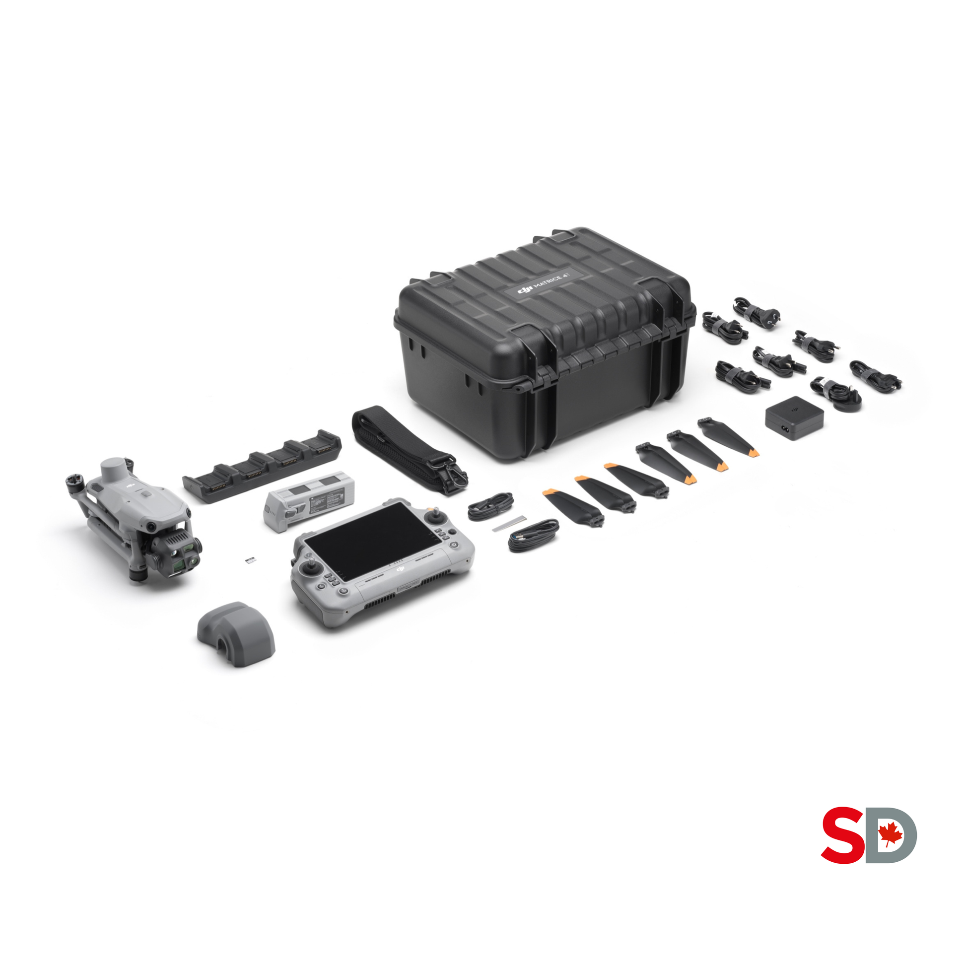 Radiometric thermal · RGB · asset-linked reporting
Choose the thermal detail, then design the aircraft system.
Matrice 4T is the practical portable choice for routine radiometric screening. H30T on Matrice 350 RTK or Matrice 400 is the high-detail choice when native 1280 × 1024 thermal imagery, stand-off and utility-scale productivity justify a larger system. Dock 3 with Matrice 4TD is the recurring-site choice only after the route, analytics, operating permissions and maintenance process are proven.
Use Matrice 4T for rapid, radiometric field screening.
- Native 640 × 512 thermal sensor with R-JPEG files.
- Paired wide, medium-tele and tele visible cameras.
- Fast deployment for multiple smaller or distributed sites.
- Best when the required defect class fits the available thermal pixels.
- Keep the original radiometric files, not only screenshots.
Use H30T when native thermal detail and stand-off matter.
- Native 1280 × 1024 radiometric thermal imagery.
- Pairs with Matrice 350 RTK or Matrice 400.
- Stronger fit for larger blocks and detailed follow-up.
- Budget the aircraft, batteries, charger and care plan separately.
- Plan logistics around a larger enterprise flight system.
Use Dock 3 only after the inspection method is proven.
- Matrice 4TD supports repeatable dock-based thermal routes.
- Define weather gates, remote supervision and exception handling.
- Verify network, power, cybersecurity and physical security.
- Integrate asset IDs and analytics before scaling.
- Canadian authorization remains an operational requirement.
Turn heat patterns into traceable maintenance decisions.
The strongest deliverable is not a colourful thermal mosaic by itself. It is a controlled evidence package that tells the client what was inspected, under which conditions, where each abnormal signature is located, how confident the analyst is and what should happen next.
Radiometric source archive
Original R-JPEG thermal frames with metadata preserved for measurement, reprocessing and auditability.
Paired RGB evidence
Visible images matched to each thermal finding so technicians can recognize the exact row, table, module and surrounding condition.
Anomaly register
A structured table with asset ID, coordinates, temperature observations, pattern, priority, confidence and recommended field checks.
GIS issue layer
GeoJSON, KML, shapefile or platform layer that lets the O&M team filter and navigate findings spatially.
Thermal map or mosaic
A site-level visualization useful for coverage and communication, with the individual radiometric frames retained for detailed review.
Executive report
A concise PDF that documents conditions, coverage, key risks, limitations, priority findings and the required next actions.
Do not launch until sunlight, wind and operating state are acceptable.
IEC TS 62446-3 defines outdoor infrared thermography for operating PV modules and plants, including equipment, ambient conditions, procedure, reporting and personnel qualification. Use it with the owner’s contract and site-specific method statement rather than relying on a generic drone route.
| Quality gate | Recommended planning rule | Why it matters | Field action |
|---|---|---|---|
| Plane-of-array irradiance | Use at least 600 W/m² as the IEC-based minimum reference and define the project target above that where needed. Core gate | Higher, stable irradiance creates stronger and more comparable thermal contrast. | Measure or obtain trustworthy site irradiance and log it throughout the inspected blocks. |
| Cloud stability | Avoid rapidly moving cloud and pause after a major irradiance change. | Modules may require approximately 5–15 minutes to reach a new thermal equilibrium after conditions change. | Mark the affected time, wait for stability and repeat questionable rows. |
| Wind | IEC-based guidance uses a maximum reference around 28 km/h; many projects should use a lower operational limit. | Wind cools modules unevenly, reduces temperature contrast and affects aircraft control. | Log average and gust wind at array height and stop when the project limit is exceeded. |
| Plant operating state | Inspect modules and circuits while operating under meaningful load. | Electrical losses need current flow to create detectable thermal differences. | Coordinate with O&M, record inverter and string state, and flag unavailable blocks. |
| Module surface | Require visible, unobstructed modules unless the objective specifically covers snow, soiling or vegetation. | Snow, ice, water, shadows, vegetation and heavy soil can hide defects or create non-electrical temperature patterns. | Document exclusions and capture RGB evidence of the condition. |
| Viewing geometry | Keep the camera as close to normal to the module surface as practical while avoiding sun and self-reflections. | Low angles increase reflection, mixed pixels and apparent temperature error. | Validate the route over a representative row and repeat from a second angle when reflection is suspected. |
| Thermal span and focus | Use radiometric mode, confirm focus and avoid clipping the hottest or coolest values. | Automatic display palettes can look convincing while hiding poor radiometric capture. | Review original R-JPEG frames and measurement metadata before leaving the site. |
Scope, control, capture, verify and close the maintenance loop.
Build the workflow around the plant’s asset hierarchy and maintenance system. A perfect image that cannot be tied to the correct module or work order has limited operational value.
Define the inspection objective.
Separate commissioning, annual preventive maintenance, warranty review, production-loss investigation and post-event inspection. Each objective needs different evidence and acceptance criteria.
Prepare the asset map.
Obtain current block, row, table, module, string, combiner and inverter records. Resolve naming conflicts before flight so findings can be actioned.
Set the weather and load gates.
Define minimum plane-of-array irradiance, maximum wind, cloud stability, plant operating state and the pause or abort rules for changing conditions.
Design and validate the route.
Calculate height, speed, direction, gimbal angle, image interval and overlap from the required thermal detail, module geometry and obstacle environment.
Collect thermal and RGB together.
Capture radiometric thermal evidence and visible context in the same controlled mission. Log irradiance, wind, ambient conditions and tracker position.
Complete field quality control.
Check coverage, focus, blur, reflections, temperature span, file integrity and asset visibility before leaving the site. Re-fly questionable blocks immediately.
Classify without overdiagnosing.
Identify the thermal signature, suspected asset and priority. Keep possible causes separate from confirmed root causes and assign the correct electrical follow-up.
Deliver and close the loop.
Publish the report, GIS layer, image package and limitations. Track technician findings, corrected assets and false positives to improve future inspection rules.
Calculate thermal pixels per asset—not simply hectares per hour.
The route must produce enough resolved thermal detail for the anomaly class promised in the contract. Cell-level, substring-level, module-level and string-level inspection are not interchangeable. Validate the planned altitude and speed with a representative test strip before the full mission.
Map every accessible module under one consistent thermal condition.
Use a systematic route to locate module, substring, string and row-level anomalies across the full inspected block.
- Fly parallel to the module rows where practical.
- Keep height, speed and gimbal geometry consistent.
- Capture enough overlap for complete coverage and reliable geolocation.
- Use the same asset naming and route conventions between visits.
- Do not trade away thermal pixels merely to maximize hectares per battery.
Revisit selected findings with more thermal pixels and better context.
A second slower or lower mission can clarify signatures that were too small, reflective, partly occluded or difficult to associate with the asset register.
- Capture paired thermal and RGB close-ups.
- Change the viewing angle to test for reflection artifacts.
- Include junction-box and connector regions where safe and visible.
- Record the same finding from more than one frame.
- Keep the aircraft and lens clear of direct solar exposure limits.
Convert aerial findings into confirmed maintenance actions.
Thermal imagery should direct qualified technicians to the highest-value checks rather than replace the electrical workflow.
- Verify the exact row, table, module and string.
- Compare SCADA, inverter and string-level performance data.
- Inspect shading, vegetation, soiling, glass and frame condition.
- Use current, voltage, insulation, I-V or connector tests as appropriate.
- Record confirmed cause, repair and post-repair status.
| Planning variable | What to define | Failure risk when ignored |
|---|---|---|
| Inspection granularity | Whether the client expects row, string, module, substring or cell-level signatures | A route optimized for throughput may not resolve the promised defect class |
| Sensor and lens | Native detector resolution, field of view, focus range, radiometric format and measurement mode | Super-resolution or a colourful display can be mistaken for true detector detail |
| Module geometry | Module dimensions, fixed tilt or tracker angle, row spacing and terrain | Mixed pixels, blocked sightlines and inconsistent footprints |
| Height above modules | Distance from the thermal camera to the module plane—not only AGL | Thermal pixel count changes with terrain and tracker position |
| Speed and image interval | Settings that avoid blur and give repeated views of each asset | Gaps, weak geolocation and one-frame false positives |
| Route direction | Parallel-to-row production path plus targeted cross-row or oblique follow-up | Inconsistent asset order and reflection patterns |
| Gimbal angle | Near-normal view to the module surface without sun, sky or aircraft reflection | False hot or cold areas caused by reflected radiation |
| Overlap | Enough longitudinal and side coverage for complete inspection and spatial products | Uninspected gaps and weak image-to-asset matching |
| Obstacles and site operations | Transmission lines, trackers, fences, weather stations, vegetation, roads, workers and maintenance vehicles | Collision risk, interrupted routes and uncontrolled people proximity |
| Tracker state | Freeze or document tracker angle where possible | Changing geometry between blocks undermines comparability |
Portable, high-detail or automated: build around the inspection objective.
Sensor resolution matters, but so do focus, radiometric file support, flight time, site access, weather rating, aircraft logistics, repeatability and analyst workflow. Compare the complete system rather than a thermal-resolution number alone.
DJI Matrice 4T
A compact multi-sensor aircraft for rapid solar O&M deployment, module-level screening and visible follow-up.
- 640 × 512 native radiometric thermal sensor.
- R-JPEG files with spot and area measurement.
- 30 Hz thermal capture and paired visible cameras.
- Published high-gain accuracy reference of ±2°C or ±2%, whichever is greater.
- Best fit: portable teams, distributed assets and rapid follow-up.
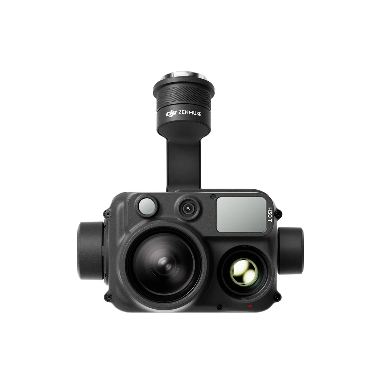
DJI Zenmuse H30T
A native 1280 × 1024 thermal payload for larger Matrice aircraft and demanding utility-scale inspection.
- 1280 × 1024 native R-JPEG thermal imagery.
- 12 μm pixel pitch and 30 Hz capture.
- High-gain, low-gain and optional infrared density-filter ranges.
- Sun-burn protection is supported, but solar reflections still require careful geometry.
- Best fit: detailed utility-scale work and greater stand-off.

DJI Matrice 4TD
The Dock 3-compatible thermal aircraft for repeatable site missions and remote fleet workflows.
- 640 × 512 native thermal sensor with super-resolution output.
- IP55 aircraft rating for wider environmental deployment.
- Published 54-minute flight-time benchmark under controlled conditions.
- Battery is listed separately in the public standalone package.
- Best fit: approved recurring routes and remote site programs.
| Category | Matrice 4T | H30T on M350 / M400 | Matrice 4TD + Dock 3 |
|---|---|---|---|
| Native thermal detector | 640 × 512 VOx, 12 μm, 30 Hz | 1280 × 1024 VOx, 12 μm, 30 Hz Detail leader | 640 × 512 VOx with 1280 × 1024 super-resolution output |
| Thermal files | 16-bit R-JPEG and 8-bit JPEG | R-JPEG radiometric thermal photos | Radiometric thermal capture for Dock workflows |
| Thermal field of view | 45° diagonal; 53 mm equivalent | 45.2° diagonal; 52 mm equivalent | Thermal camera aligned with Matrice 4D Series inspection system |
| Measurement range | High gain −20°C to 150°C; low gain 0°C to 550°C | High and low gain with optional density-filter ranges up to 1600°C under stated configurations | Confirm current camera mode and mission requirements for the site |
| Visible context | Wide, medium tele and tele cameras | Wide, zoom and laser-rangefinder payload functions | Wide, medium tele, tele and thermal cameras |
| Deployment | Fast portable aircraft; one operator team | Larger aircraft, batteries, charger and transport cases | Fixed-site hardware, network, power, security and remote operations |
| Best fit | Routine portable screening and distributed sites | Utility-scale detail, stand-off and complex enterprise inspection | Approved recurring routes and high-frequency site programs |
| Key caveat | 1280 × 1024 is super-resolution, not native detector resolution | Payload price excludes the aircraft system | Automation does not create Canadian BVLOS authorization |
The drone is only one part of the inspection system.
Bring the instruments, records and site coordination required to defend the conditions and turn an anomaly into a work order. Missing asset maps or irradiance records can reduce the value of otherwise strong imagery.
Measure and record what changes the thermal result.
- Plane-of-array irradiance meter, pyranometer or validated site irradiance data.
- Wind, gust and ambient-temperature measurement.
- Current module layout, row and table numbering, string maps and inverter list.
- SCADA or O&M confirmation of operating blocks and curtailment.
- Flight batteries, charging, landing pad, cones, PPE, radios and spare media.
- Site emergency contacts, access rules and electrical hazard briefing.
Avoid an image set that nobody can locate or trust.
- Outdated row names or missing module serial-number relationships.
- No reliable irradiance log for the actual inspection period.
- Unrecorded tracker movement, inverter outages or string disconnection.
- Thermal screenshots exported without original radiometric files.
- Automatic hotspot labels accepted without human QA.
- No technician feedback loop to confirm false positives and root causes.
Describe the signature first. Diagnose only after field confirmation.
Use a controlled classification vocabulary that separates observed thermal shape, possible causes and required confirmation. This protects the client from false certainty and makes analyst performance measurable.
| Observed signature | Possible interpretations | Recommended follow-up |
|---|---|---|
| Single hot cell or small cell group | Cell damage, interconnection issue, local shading, contamination or reflection | Repeat from another angle; inspect RGB; compare electrical performance and module condition |
| Hot substring pattern | Bypass-diode operation, substring mismatch, shading or internal module condition | Confirm module and string; review shade; perform qualified electrical testing |
| Entire module warmer than neighbours | Open circuit, low current, connection issue, mismatch, different operating condition or soiling | Check string data, connectors, junction box, module identity and surrounding modules |
| Repeated modules across one string | String outage, fuse, combiner, connector, inverter input or configuration issue | Correlate with SCADA and string current; inspect combiner and connections under site procedure |
| Hot junction-box or connector region | Connection resistance, diode area, damaged connector or reflected heat source | Escalate to qualified electrical inspection; do not open live equipment through the drone workflow |
| Cold or irregular patch that moves with angle | Sky, cloud, sun, aircraft or landscape reflection | Capture a second angle and review RGB before creating an anomaly record |
| Row-edge or vegetation-shaped difference | Shadow, plant growth, snow, soil, water or airflow effect | Classify as environmental until electrical evidence supports otherwise |
| Broad inverter or combiner heat area | Normal load, ventilation issue or electrical fault | Compare like-for-like equipment and involve qualified O&M staff with safe stand-off |
Preserve radiometry, pair the evidence and control the analytics.
DJI Thermal Analysis Tool 3 can read supported infrared images and temperature information, including spot and area measurements. Solar-specific anomaly detection, asset matching and work-order integration still require a validated process or third-party analytics.
Retain the original radiometric images.
- Keep R-JPEG files, timestamps, aircraft logs and mission folders unchanged.
- Store the display palette separately from the temperature data.
- Record emissivity, reflected-temperature and environmental assumptions where used.
- Preserve the mapping between thermal and visible images.
- Use checksums, version control or controlled cloud storage for auditability.
Review detections before they become client findings.
- Reject reflections, shadows, moving clouds and mixed-pixel artifacts.
- Require repeated evidence where the anomaly is small or uncertain.
- Match each accepted finding to the correct asset hierarchy.
- Use client-defined severity or priority rules, not generic colour labels.
- Track technician confirmation to improve future thresholds and models.
Use maps to navigate—not to replace source frames.
- Create thermal maps or mosaics for coverage and site-level context.
- Keep the radiometric frame linked to every map point.
- Export coordinates in the agreed reference system.
- Include row, table, module, string, combiner and inverter fields where available.
- Test the GIS layer in the client’s actual maintenance platform.
Measure the reliability of the inspection program.
- Inspected modules versus planned modules.
- Blocks excluded for weather, outage, obstruction or data quality.
- Reflight rate and analyst-review time.
- Confirmed faults, false positives and unresolved findings.
- Time from capture to report and from finding to closure.
Package the result for each person who must act on it.
Owners need risk and production context. O&M managers need work orders. Technicians need exact assets and evidence. Engineers and warranty teams need methods, source files and limitations. One generic PDF rarely serves every role well.
Risk and production priorities.
Summarize inspected capacity, high-priority findings, affected blocks, limitations and the recommended O&M response.
Executive PDF + dashboardActionable work orders.
Provide asset IDs, coordinates, paired images, priority, suspected pattern, confidence and the exact field checks required.
Anomaly register + GISEvidence at the module or string.
Deliver clear thermal and RGB frames, surrounding context, operating conditions and the link to the site naming system.
Field evidence packageTraceable, condition-controlled evidence.
Document methods, dates, operating state, exclusions and repeatability. Keep diagnosis and claim eligibility separate from the thermal observation.
Audit-ready recordStructured data and limitations.
Share machine-readable coordinates, temperature observations, image metadata, equipment details and known uncertainty.
CSV / GeoJSON / source filesRepeatable inspection operations.
Track weather success rate, reflight rate, analyst time, false positives, confirmed faults and time from detection to closure.
Program KPI package| Report component | Minimum content |
|---|---|
| Inspection identity | Site, owner, blocks, inspected capacity, date, local time, crew and revision |
| Method | Aircraft, thermal sensor, firmware, lens, flight geometry, speed, file format and analysis tools |
| Environmental log | Plane-of-array irradiance, ambient temperature, wind, cloud condition and major changes |
| Plant state | Operating blocks, outages, curtailment, tracker position and unavailable circuits |
| Coverage and exclusions | Planned versus completed blocks, missing rows, obstruction, weather pauses and rejected data |
| Anomaly table | Unique ID, asset hierarchy, coordinates, thermal pattern, temperature observation, priority, confidence and status |
| Evidence | Paired radiometric thermal and RGB frame with scale, timestamp and surrounding context |
| Recommended action | Field confirmation method, responsible party, target date and escalation path |
| Limitations | What the drone could not see, what was not operating and what cannot be concluded from thermography alone |
| Source package | R-JPEG archive, RGB images, GIS layer, CSV register, flight log and report |
The solar site may be remote, but the operation is not automatically Basic.
Determine the category from airspace, people, visual line-of-sight, proximity to aerodromes, aircraft declaration and the proposed remote-operation model. Matrice 4T, Matrice 4TD, Matrice 350 RTK and Matrice 400 are small RPAS when operated within their approved weight configurations, but the mission privileges still depend on the pilot and operation.
| Operational question | Canadian planning point | Solar-farm implication |
|---|---|---|
| Registration and certificate | Drones from 250 g to 25 kg require registration and the appropriate pilot certificate | Carry proof and verify every aircraft in the inspection fleet |
| Basic operation | All Basic conditions must be met, including uncontrolled airspace, VLOS and required distance from uninvolved people | A rural site may qualify only when workers, roads, airspace and aerodrome conditions are controlled |
| Advanced operation | Advanced privileges include controlled airspace with permission, closer operations and eligible EVLOS or sheltered operations | Coordinate workers, land access and NAV CANADA authorization where applicable |
| EVLOS | Current rules allow specified EVLOS operations with an Advanced certificate and trained visual observer in uncontrolled airspace | Can support long blocks, but distance, people and observer requirements still apply |
| Lower-risk BVLOS | Level 1 Complex certification, an RPOC and an eligible operational framework are required | Dock ownership alone does not authorize remote BVLOS solar inspection |
| Site workers | Classify people as involved or uninvolved based on briefing, consent and operational control | Create exclusion zones, communication and stop-work procedures around active maintenance |
| Roads and neighbouring land | Plan for vehicles, public access, property boundaries and emergency landing areas | Large arrays often have roads and perimeter activity that interrupt otherwise simple grids |
| Privacy and data security | Control collection, access, storage, cloud location and external sharing | Solar assets, substations and electrical layouts may be commercially or operationally sensitive |
Build the annual inspection window around sunlight and surface condition.
A fixed annual calendar date can fail when cloud, low sun, snow, frost, vegetation or curtailment prevents valid comparison. Use a planned window with backup dates and site readiness criteria.
Baseline after snowmelt.
Inspect after modules are clear and the plant is operating under stable sun. Watch for residual snow, water, frost, vegetation and winter damage.
Strong irradiance and heat.
High solar input can improve contrast, but heat, glare, wind, battery temperature and technician exposure require operating controls.
End-of-season and vegetation review.
Useful for annual preventive maintenance and post-storm checks when sunlight remains adequate and leaf or vegetation shadows are controlled.
Use selectively.
Low sun, snow, ice and short stable windows can limit standard thermography. Do not compare a snow-covered block with a clear-surface baseline.
Compare the complete inspection system and annual utilization.
Public SpeedyDrone references were checked July 21, 2026. Final quotes should confirm care plans, aircraft compatibility, batteries, charging, RTK, software, analytics, training, tax, installation, availability and the required Canadian operating model.
Matrice 4T aircraft package.
- Public SpeedyDrone reference checked July 21, 2026.
- Compact multi-sensor aircraft with radiometric thermal camera.
- Confirm batteries, charging, care plan, RTK accessories and stock.
- Suitable for portable inspection and distributed site programs.
- Tax, training, software and analytics are additional.
Zenmuse H30T payload.
- Public SP option checked July 21, 2026.
- Matrice 350 RTK or Matrice 400 platform required.
- Aircraft, batteries, charging and care are separate.
- Native 1280 × 1024 thermal imagery.
- Confirm current compatibility, package and lead time before order.
DJI Dock 3 listing.
- Public dock-body reference checked July 21, 2026.
- Matrice 4TD, batteries, installation, civil work and network may be additional.
- Cloud software, analytics and integration scope vary.
- Requires site security, power, connectivity and operating procedures.
- Canadian remote-operation authorization must be planned separately.
| Additional system item | Public reference | Planning impact |
|---|---|---|
| Matrice 400 SP Plus Full Package | CA$14,099 | Aircraft platform for H30T; confirm included battery station, battery and current care package |
| Matrice 4TD standalone | CA$11,628 | Dock-compatible aircraft listing; battery not included in the public standalone package |
| Additional batteries and charging | Configuration dependent | Determines daily throughput, site transport and turnaround between blocks |
| Irradiance and weather instruments | Project dependent | Necessary for defensible field-condition records |
| Thermal analysis and solar analytics | Licence or service dependent | DJI Thermal Analysis Tool supports image measurement; solar asset matching and automated classification may require additional software |
| Training and operating procedures | Scope dependent | Pilot skill, thermography knowledge, solar asset mapping, QA and electrical coordination drive reliability |
Select the platform that closes the maintenance loop.
The best thermal drone is the one that produces the promised anomaly detail, runs legally and safely at the site, links findings to real assets and fits the O&M team’s capacity to verify and repair them.
Start with Matrice 4T.
Use a standardized portable kit for multi-site screening, rapid dispatch and module-level reports. Validate the promised resolution on representative arrays.
Matrice 4TBuild around H30T and a larger Matrice platform.
Choose native 1280 × 1024 thermal detail when large blocks, inspection distance, image quality and downstream analytics justify the larger system.
H30T + M350 / M400Prove Dock 3 with a controlled pilot.
Validate route quality, weather gates, data transfer, analytics, maintenance and authorization before promising recurring remote inspection.
Dock 3 + M4TDSell a defined deliverable—not flight time.
Package the method, asset register, report, GIS layer, turnaround and field-verification pathway. Avoid guarantees based only on sensor resolution.
Service designIntegrate with SCADA and CMMS first.
Map drone findings into the systems already used to assign work, confirm faults, record repairs and monitor recurring assets.
O&M integrationUse a pilot inspection before buying.
Test one representative block, review confirmed-fault rates and calculate annual utilization before committing to H30T or Dock infrastructure.
Assessment firstEquipment, weather, flight planning and reports answered.
What is the minimum irradiance for a solar farm thermal drone inspection?
IEC TS 62446-3-based planning commonly uses at least 600 watts per square metre measured in the plane of the array. Higher and stable irradiance usually improves thermal contrast. Record irradiance during the mission, pause when clouds create rapid changes, and apply the project-specific acceptance criteria rather than treating one threshold as a guarantee.
Should the solar plant be operating during infrared inspection?
Yes. Outdoor PV thermography is intended for modules and plants in operation. The inspected circuits should be carrying meaningful current under stable sunlight so electrical losses can create measurable thermal differences. Coordinate with the owner or O&M team, record operating state and SCADA conditions, and do not energize or switch equipment unless qualified and authorized.
Is DJI Matrice 4T suitable for solar panel inspection?
Yes. Matrice 4T is a compact radiometric thermal platform with a native 640 by 512 VOx sensor, paired visible cameras, R-JPEG capture and spot or area measurement. It is a practical fit for portable inspections and smaller or distributed sites. Mission altitude and speed must still produce enough thermal pixels on each module for the required anomaly class.
Is Matrice 4T thermal resolution natively 1280 by 1024?
No. The Matrice 4T thermal sensor is natively 640 by 512. DJI provides a super-resolution image mode up to 1280 by 1024, but this does not change the native detector resolution. Procurement documents and inspection specifications should distinguish native sensor resolution from generated super-resolution output.
When is Zenmuse H30T better than Matrice 4T?
Zenmuse H30T is the stronger choice when the project needs native 1280 by 1024 radiometric imagery, greater stand-off flexibility, a larger Matrice platform, longer endurance options or higher-detail utility-scale inspection. It is a payload, so the aircraft, batteries, charging, care plan and transport system must be budgeted separately.
Can a thermal drone identify the exact cause of a hot module?
Not reliably by itself. A thermal pattern can identify and prioritize an abnormal module, substring, string, junction-box area or row, but reflection, shading, soiling, weather and operating conditions can create similar signatures. Confirm root cause with qualified O&M or electrical personnel using visual inspection, string data, current and voltage tests, I-V tracing or other appropriate methods.
What altitude should be used for solar thermal inspection?
There is no universal altitude. Calculate it from the thermal camera field of view, module dimensions, array tilt, required pixels per module or cell, obstacle clearance, row spacing and the anomaly class the client expects. Validate the planned height with sample imagery before committing to production throughput.
Do I need RTK for solar farm thermal inspection?
RTK is useful for repeatable routes, consistent geolocation and linking findings to GIS, but it does not solve asset identification by itself. A reliable program also needs current row, table, module, string, combiner and inverter records. Where precise coordinates matter, define the reference system and validate the result.
Can DJI Dock 3 automate recurring solar inspections?
DJI Dock 3 with Matrice 4TD can automate approved recurring routes, upload data and support remote fleet workflows. Automation does not authorize unattended or BVLOS operations in Canada. The operator must still meet the applicable Transport Canada certificate, airspace, visual-line-of-sight or complex-operation requirements, site controls and weather procedures.
What should the final solar thermal inspection report include?
The report should identify the site and inspected blocks, date and time, weather and irradiance, plant operating state, equipment and settings, coverage, exclusions, anomaly table, paired thermal and RGB evidence, asset IDs or coordinates, priority, confidence, recommended field checks and clear limitations. Raw radiometric files and a GIS-compatible issue layer should be retained when required.
How often should a solar farm be inspected with thermal drones?
Frequency should be risk-based and aligned with the owner, warranty and O&M plan. Common trigger points include commissioning, an early operational baseline, annual preventive maintenance, end-of-warranty review, unexplained production loss and inspection after severe weather, construction activity or electrical events.
Can solar panels be thermally inspected on a cloudy or snowy day?
Standard outdoor infrared comparison is usually weak when irradiance is low or changing quickly. Snow, ice, water, heavy soiling and moving cloud shadows can dominate the thermal response or hide the module surface. Reschedule unless the inspection method, objective and reporting limitations specifically account for those conditions.
What Canadian drone certificate is needed for a solar farm inspection?
The category depends on the operation, not the commercial purpose. A Basic operation may be possible when every Basic condition is met, including uncontrolled airspace, visual line-of-sight and required separation from uninvolved people. Controlled airspace, closer operations, EVLOS, sheltered operations or other privileges may require an Advanced certificate and the correct aircraft declaration. Lower-risk BVLOS or special operations require additional authorization.
Verify the standard, sensor and Canadian operation.
Send the site capacity, module layout and required anomaly detail.
Include the province, site megawatts, fixed-tilt or tracker design, module and inverter type, row and asset records, airspace, inspection frequency, expected defect granularity, existing aircraft, desired GIS or report format and whether the work will be portable or dock-based. SpeedyDrone can prepare a Matrice 4T, H30T or Dock 3 workflow assessment, Canadian quote, financing review, training plan or Toronto demonstration.


