


Orchard Aerial Mapping and Spraying with DJI Agras T50
A complete workflow for apple orchards, vineyards, berries, stone fruit and other perennial crops: survey the block, build a 3D route, analyze crop variability, validate the treatment decision, calibrate the T50, apply legally, verify coverage and maintain records.
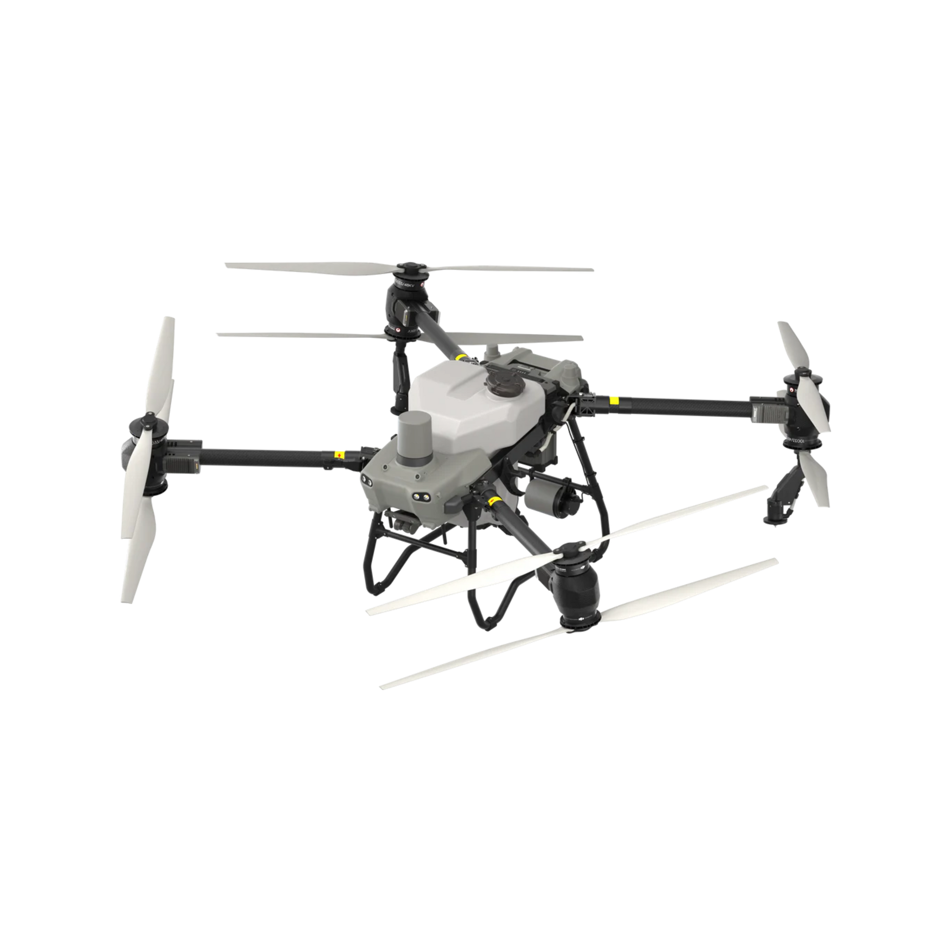
DJI Agras T50
FPV mapping, RTK route generation, dual atomizing spraying, optional four-sprinkler orchard flow, dual radar and binocular vision.
Map first. Decide second. Spray only after the legal and agronomic checks.
Orchard mapping and orchard spraying are related but separate services. A map can define trees, rows, terrain, obstacles and treatment zones. It does not prove that a pesticide is required, select the product, replace the registered label or authorize aerial application.
Mavic 3M observes. Agras T50 applies.
Mavic 3M collects 20 MP RGB imagery and four multispectral bands: green, red, red edge and near infrared. T50 performs spraying or spreading. DJI SmartFarm can support orchard reconstruction, fruit-tree counting, route planning and prescription-map workflows, but interpretation, ground-truthing and compatibility checks remain necessary.
Observe, map, analyze, decide, apply, verify, record and improve.
A reliable orchard program keeps imagery, agronomy, aviation, pesticide compliance and equipment operation as connected but distinct steps.
Observe
Scout canopy condition, terrain, standing water, pests, disease symptoms and access.
Map
Capture boundaries, rows, trees, elevation, obstacles and sensitive areas.
Analyze
Review RGB and multispectral outputs, then ground-truth anomalies in the block.
Decide
Select the treatment, rate and area only after agronomic and label review.
Apply
Use a validated route, calibrated swath, suitable droplets and compliant crew workflow.
Verify
Check spray pattern, coverage, missed zones, drift concerns and route completion.
Record
Save map, route, product, rate, weather, crew, application and maintenance records.
Improve
Compare results and refine route spacing, coverage, logistics and scouting priorities.
Use T50 for operational routes or Mavic 3M for deeper crop data.
The best mapping platform depends on whether the immediate goal is route creation or higher-resolution crop analysis.

Operational mapping in the orchard.
T50 supports FPV mapping with RTK, area and boundary surveys, field routes and 3D orchard routes. DJI states that area surveying supports slopes up to 20 degrees.

Higher-resolution reconstruction and analysis.
SmartFarm supports orchard reconstruction, fruit-tree counting, crop monitoring and prescription-map workflows using supported survey-aircraft imagery.
| Mapping task | T50 with RC Plus and RTK | Mavic 3M with SmartFarm |
|---|---|---|
| Primary purpose | Rapid operational mapping and route creation | RGB and multispectral orchard reconstruction and analysis |
| Imagery | FPV mapping for boundaries, obstacles and routes | 20 MP RGB plus green, red, red-edge and near-infrared bands |
| Orchard functions | 3D orchard routes, tree and obstacle identification, route editing | Fruit-tree counting, crop indices, elevation analysis and prescription maps |
| RTK | Required for T50 FPV mapping | Standard RTK module supports centimetre-level positioning under suitable conditions |
| Best fit | Fast route setup for a known orchard block | Seasonal scouting, crop variability analysis and detailed orchard records |
| Critical limitation | Not a substitute for detailed multispectral agronomy | Data does not automatically determine the product, rate or legal application |
A usable map must include more than tree rows.
Mapping should support the flight route, the pesticide decision, the safety plan and the provincial documentation requirements.
Block geometry
- Property and treatment boundaries.
- Rows, headlands and turning space.
- Canopy height, width and density.
- Missing trees and irregular plantings.
Terrain
- Slope and rapid elevation change.
- Terraces, ditches and low areas.
- Launch, landing and emergency sites.
- RTK and communication conditions.
Obstacles
- Power lines and guy wires.
- Poles, buildings and irrigation.
- Dead branches and overhanging limbs.
- Roads, workers, livestock and equipment.
Sensitive areas
- Homes, schools and daycares.
- Water, wells and drainage.
- Neighbouring crops and organic blocks.
- Pollinator habitat and public access.
Application zones
- Permitted and prohibited areas.
- Labelled aerial buffer zones.
- Spot-treatment or exclusion zones.
- Refill and decontamination areas.
Operational records
- Map version and survey date.
- Route version and parameter changes.
- Tree count and block area.
- Who approved the treatment plan.
Flow rate is not canopy coverage.
T50 provides a 40 L tank, 50-500 micrometre droplets, a 4-11 m published effective swath and up to 16 L/min with two sprinklers. The optional four-sprinkler arrangement reaches up to 24 L/min for higher-flow scenarios such as dense orchard canopies.

Set droplet and flow for the orchard, label and weather.
The operator must verify actual swath, overlap, deposition, penetration and drift whenever speed, height, droplets, flow or canopy conditions change.

Obstacle systems support the mission; they do not guarantee it.
DJI does not recommend relying on automatic obstacle bypass around electric or guy wires. Site survey, route editing and crew supervision remain essential.
Water volume
Do not reduce below the minimum aerial volume on the registered pesticide label. Orchard efficacy and coverage may require more volume than a simple acreage calculation suggests.
Canopy structure
Tree height, row spacing, density, leaf area, training system and target location affect route spacing, direction, flow and the number of passes.
Weather
The aircraft's wind-resistance specification is not a pesticide-application limit. Follow the label and stop when coverage, drift or safe flight is not acceptable.
Calibration
Use appropriate collection media and a repeatable calibration method to establish actual swath and coverage before pesticide work.
Verification
Inspect representative canopy zones, upper and lower surfaces, row edges, turns, gaps and terrain changes.
Not a universal replacement
Compare T50 with the orchard's existing airblast or ground system using actual coverage, water, labour, timing and compliance requirements.
Federal rules are shared. Provincial pesticide requirements are not.
Transport Canada and Health Canada requirements apply in both provinces. Ontario and Quebec then add different pesticide licences, business permits, mapping and recordkeeping obligations.
Aerial-class licensing and two-year records.
- Aerial land extermination requires a licensed Aerial-class land exterminator.
- The pesticide must be permitted for aerial application by its label.
- A record of each aerial land extermination must be prepared and kept for at least two years.
- A business applying pesticides for fee or payment may require an operator licence.
- Confirm permits, local sensitive areas and all site-specific requirements before the job.
C1 or D1 permit, CD1 certificate and a 300 m map.
- The business must hold a C1 or D1 aerial-application permit.
- The applicator must hold a CD1 certificate or work under supervision of a certificate holder.
- Treatment limits must be identified before application.
- The pilot or supervisor must have a map or aerial photograph covering 300 m around the application zone.
- Distances from sensitive elements, including school and daycare grounds, must be respected.
- An agronomic prescription is required for listed atrazine or targeted neonicotinoid uses.
| Requirement | Ontario orchard spraying | Quebec orchard spraying |
|---|---|---|
| Business or operator structure | Operator licence may be required for commercial extermination work | C1 or D1 aerial-application permit required for the business |
| Applicator credential | Aerial-class land exterminator licence | CD1 aerial-application certificate or supervised work |
| Map requirement | Operational mapping and records should identify the treatment area; verify permit conditions | Map or aerial photograph must identify permitted and prohibited areas and cover 300 m around the zone |
| Treatment boundary | Define and document the legal treatment area and buffers | Identify limits with markers or flight-line guidance before application |
| Records | Keep aerial-application records for at least two years | Maintain the required pesticide purchase and use records for the applicable permit |
| Special provincial checks | Confirm product class, permits, local ministry requirements and commercial licensing | Confirm sensitive-element distances and any required agronomic prescription |
T50 is a medium drone in Canada.
DJI publishes T50 takeoff weights of 92 kg for spraying and 103 kg for spreading at sea level. Medium-drone VLOS operations are Advanced operations or beyond.
Pilot and registration
The pilot must hold the appropriate certificate, carry proof of registration and operate within visual line of sight.
Safety Assurance
The exact T50 model and configuration must have the applicable RPAS Safety Assurance for the intended distance from people and airspace.
People separation
More than 152.4 m or 500 ft from uninvolved people is the medium-drone away-from-people category. Closer operations require the applicable declaration and permission.
Controlled airspace
Obtain air-traffic-control permission where required and verify nearby airports, heliports and military aerodromes.
Special operations
Use an SFOC when the mission falls outside the permissions available under Advanced or other applicable categories.
Transmission distance
A 2 km equipment communication specification does not authorize BVLOS. The operation must remain within the legally permitted category.
Prove the route and spray pattern before discussing chemical application.
A water-only demo is the correct first step for many orchards. It separates equipment evaluation from pesticide authorization.
What a water-only demo can test
- Launch and refill location.
- RTK, communication and route quality.
- Terrain following and obstacle plan.
- Flow, droplets, overlap and visible spray pattern.
- Battery rotation and crew timing.
- Data and recordkeeping workflow.
What it does not prove
- Pesticide efficacy or crop tolerance.
- Legal permission for a specific product.
- Compliance with a missing aerial label.
- Adequate pesticide deposition inside every canopy.
- Financing, savings or fixed cost per acre.
- Authorization for future commercial work.
From orchard survey to documented application.
The following sequence applies to both provinces, with the appropriate provincial licensing and documentation added.
1. Orchard intake
Crop, variety, block size, row spacing, canopy, slope, current sprayer, application volume and recurring problem.
2. Aviation screen
Airspace, aerodromes, people, property, Safety Assurance, pilot certificate and insurance.
3. Map the block
Use T50 or Mavic 3M to establish boundaries, elevation, trees, obstacles, sensitive zones and route geometry.
4. Treatment decision
Ground-truth the data and review the product, crop, pest, aerial label, provincial licence and agronomic requirements.
5. Route and calibration
Confirm file compatibility, route spacing, height, speed, flow, droplets, swath, overlap and refill strategy.
6. Water-only validation
Run the route with clean water, verify pattern and correct mapping or coverage issues.
7. Crew staging
Separate the clean controller area from pesticide handling, loading, batteries, PPE and decontamination.
8. Apply and monitor
Watch people, wind, route, payload, battery, communication, obstacles and abort criteria.
9. Verify and record
Inspect coverage, save the route and complete all federal, provincial, customer and maintenance records.
Build the business case around the block, not a generic cost-per-acre claim.
Orchard economics vary with canopy, water volume, terrain, refill distance, product, route density, crew, weather and seasonal utilization.
Mapping value
Orchard inventory, tree counts, boundary records, terrain information and repeatable digital routes.
Access value
Slopes, wet areas, irregular blocks and locations that are difficult for ground equipment.
Timing value
Faster mobilization for small or distant blocks when legal weather and treatment windows are narrow.
Labour and logistics
Include pilot, mixer or loader, batteries, generator, water, travel, cleaning and documentation.
Verification value
Repeatable maps and route records may improve consistency, audits, customer reporting and follow-up scouting.
Risk reserve
Budget for weather cancellation, weak coverage, licensing delays, repairs, battery replacement and low-use seasons.
Start with mapping, a water-only demo or a full deployment assessment.
Final scope and pricing depend on province, travel, orchard complexity, aircraft, software, crew and regulatory requirements.
Orchard Mapping Assessment
- Block intake and survey plan.
- T50 or Mavic 3M workflow recommendation.
- Boundary, obstacle and terrain-data requirements.
- SmartFarm and route-compatibility review.
Water-Only T50 Demo
- Site and airspace screen.
- Operational route setup.
- Water-only spray-pattern demonstration.
- Battery, refill and crew-timing review.
Orchard Deployment Assessment
- Mapping and application workflow.
- Ontario or Quebec compliance checklist.
- Equipment, power, training and SOP plan.
- Purchase, leasing or service-first review.
Questions from Ontario and Quebec growers.
Can DJI Agras T50 map an orchard by itself?
Yes. DJI states that T50 supports FPV mapping with RTK, including area and boundary surveying, field routes and 3D orchard routes. DJI's T50 FAQ states that area surveying supports slopes up to 20 degrees. For higher-resolution RGB and multispectral analysis, fruit-tree counting and prescription-map workflows, use Mavic 3M with DJI SmartFarm Web.
What is the difference between T50 mapping and Mavic 3M mapping?
T50 mapping is designed to create operational boundaries and routes directly through the RC Plus workflow. Mavic 3M captures 20 MP RGB imagery and four 5 MP multispectral bands for higher-resolution reconstruction and crop-analysis workflows. Mavic 3M data does not automatically become an agronomic prescription.
Can T50 legally spray pesticides in Ontario orchards?
Potentially, but only when the pesticide permits aerial application and all Health Canada label and policy requirements, Transport Canada rules, Ontario Aerial-class licensing, PPE, insurance, crew separation and recordkeeping requirements are met.
What licence is required for aerial pesticide application in Quebec?
Quebec states that the business must hold a C1 or D1 aerial-application permit. The person applying the pesticide must hold a CD1 aerial-application certificate or work under the supervision of a certificate holder. Other product, site and environmental requirements may also apply.
Does Quebec require an orchard map before aerial pesticide spraying?
Quebec requires the pilot or supervising person to have a map or aerial photograph identifying permitted and prohibited application areas and covering 300 metres around the application zone. Treatment boundaries must also be identified before application.
How much liquid can T50 carry?
DJI specifies a 40-litre spray tank with a 40-kilogram operating payload. The standard two-sprinkler system reaches up to 16 litres per minute, while the optional four-sprinkler arrangement reaches up to 24 litres per minute under specified conditions.
Is a water-only orchard demonstration the same as pesticide application?
No. A water-only demonstration can be used to evaluate mapping, route planning, aircraft handling and spray-pattern setup without applying a pesticide. Aviation, site, insurance and safety requirements still apply, and the demonstration does not authorize later pesticide use.
Can multispectral data tell a grower exactly where to spray?
Not by itself. Mavic 3M can collect RGB and multispectral data that may reveal variability in crop condition, but a qualified person must interpret the data, ground-truth the result, decide whether treatment is appropriate and verify that any prescription map and route are compatible with the selected software and application system.
How far must T50 remain from uninvolved people in Canada?
For medium-drone VLOS operations, Transport Canada identifies more than 152.4 metres or 500 feet from uninvolved people as the away-from-people category. Closer operations require the applicable Safety Assurance declaration and operating permissions. The exact aircraft configuration and intended operation must be verified before flight.
Can T50 replace an airblast sprayer in every orchard?
No. T50 may complement or replace selected applications where access, terrain, timing or localized treatment create value, but canopy coverage, water volume, droplet size, penetration, drift, label requirements and orchard geometry must be tested on the actual block.
What should an Ontario or Quebec orchard fit-check include?
It should include crop and variety, orchard acreage, row spacing, canopy height and density, terrain and slope, obstacle map, sensitive areas, current sprayer, water volume, product label, licensing, pilot and crew status, insurance, charging and refill logistics, and the intended mapping or application workflow.
Verify the workflow before every season.
Request an Ontario or Quebec orchard fit-check.
Send the orchard location, crop, acres, row spacing, canopy height, slope, current sprayer, application volume, product label, licensing status and whether the goal is mapping, a water-only demo, equipment ownership, financing or deployment support.


