


Resource updated October 6, 2026 · Canadian stockpile survey workflow
A useful stockpile survey explains the surface, the base and the confidence behind the number. This guide follows the work from the first flight plan to a volume report another operator can reproduce.
Quick answer: Use the DJI Matrice 4E to capture sharp, overlapping mapping images, then reconstruct and check a 3D model in DJI Terra. Trace the pile toe, choose a defensible base plane and save the cut and fill results. Report cubic metres with control evidence, exclusions and the measurement method; convert to tonnes only with an approved bulk-density value.
This workflow suits visible, accessible stockpile surfaces at aggregate yards, construction sites, mines and municipal material depots. It can reduce climbing on unstable piles and preserve a dated inventory record. Its hardest questions are often underneath the material: what was the ground level, where does this pile end, and did the survey capture one coherent moment?
Navigate this resource
- Define the inventory decision
- Matrice 4E and Terra roles
- RTK, checkpoints and coordinates
- Plan the capture
- Check before leaving site
- Process and inspect in Terra
- Select the boundary and base
- Accept or reject the result
- Convert volume to tonnes
- Report and repeat the survey
- Troubleshoot difficult piles
- Plan equipment and cost
- Canadian operations and checklist
- Frequently asked questions
1. Define the inventory decision before flying
Start with the question the report must answer. A yard supervisor checking whether a gravel pile will cover next week’s work needs a different acceptance process from a contractor submitting a payment quantity or an accountant closing month-end inventory. Agree on the intended use, reviewer and tolerance before choosing altitude or buying equipment.
Make a pile register with a persistent ID, material name, storage location and responsible contact. Record whether the result represents loose material above an existing pad, material in a bunker, or earthwork between dated surfaces. These are different measurement problems even when the software presents the same volume button.
Choose a capture window with the site supervisor. If a loader removes material halfway through the mission, photographs describe different pile shapes. Agree on an inventory cut-off time, pause movement where practicable, and record any deliveries, removals or unavoidable activity during acquisition. A date without a time can be insufficient for an active yard.
For financial, contractual or regulated use, establish the required survey procedure and qualified review. A drone-derived volume is evidence within that procedure. It does not by itself establish an audited inventory balance, a legal boundary or an accepted payment quantity.
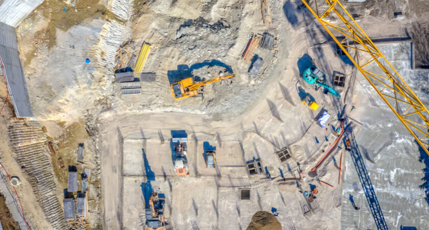
For a broader rollout involving staff, procedures and procurement, use the construction drone program guide. The resource here concentrates on one deliverable: a defensible stockpile volume and a comparable repeat survey.
2. Give the aircraft and software distinct jobs

Capture a measurable surface
The Matrice 4E’s wide camera uses a 4/3-inch CMOS sensor with 20 MP effective pixels and a mechanical shutter. Its minimum JPEG photo interval is 0.5 seconds; JPEG + RAW has a longer minimum interval. Use the correct wide-camera mapping configuration rather than assuming every camera or file mode behaves identically.
DJI publishes up to 49 minutes of flight time under its specified windless test conditions. Treat that as a manufacturer maximum, then plan actual reserve, transit, wind and battery changes for the site.
DJI Terra supplies the reconstruction and measurement environment. For this workflow, select metric visible-light outputs such as a 3D mesh, point cloud and orthomosaic; use the mesh for Terra’s stockpile volume measurement. A DSM represents the visible surface, including objects on it. A classified DEM is not evidence that the ground hidden under a pile has been recovered.
Terra Standard includes the visible-light reconstruction and annotation tools relevant to ordinary stockpile work in DJI’s current feature list. Confirm the exact licence, workstation and required exports before ordering. Extra visual rendering features do not resolve a missing toe or unknown floor.
DJI’s Matrice 4 specifications govern capture capabilities. DJI Terra’s feature information governs processing capabilities. Neither is a guaranteed accuracy percentage for your completed inventory.
3. Establish control and independent checks
RTK improves the positioning recorded with images. Ground-control points constrain the reconstruction. Independent checkpoints test the result without helping fit it. Keep those roles separate: small residuals at points used as control are not an independent demonstration of accuracy.
Confirm a correction source that works at the site, such as an appropriate network RTK service or compatible local base station. Record the source, connection status and image positioning status. When using a local base, preserve its coordinate basis and setup information. Repeating an unknown or inconsistent base position can make successive datasets difficult to align.
Place checkpoints on stable, safely accessible surfaces where they are clearly identifiable in several images. Distribute checks across the work area and relevant elevation range rather than clustering every target next to take-off. The project’s survey lead should set the quantity, distribution, measurement method and acceptance tolerance; there is no universal checkpoint count that proves every stockpile.
In Terra, designate check points as checks, retain their known coordinates and inspect horizontal and vertical discrepancies. If you use a point to adjust the model, it has become control for that processing run. Keep a separate check set or obtain new independent evidence before claiming validation.

Choose the correction method for the site
A local station can be useful where a network service is unsuitable. It still needs a controlled setup and a documented coordinate reference. Confirm compatible operating mode and required pole or tripod accessories separately; a correction source does not replace independent survey checks.
Make coordinates part of the handover
Record horizontal reference frame, realization and epoch where applicable, projection or local grid, vertical datum, geoid treatment and units. Canadian GNSS heights and a project’s orthometric elevations may require a defined conversion. Do not mix an ellipsoidal-height surface with an orthometric-height base and then interpret the difference as material.
Natural Resources Canada’s reference-system guidance explains why frame and epoch metadata matter. Agree on the client’s actual reference system; “Canadian coordinates” is not a sufficient specification.
4. Plan for the crest, steep faces and full toe
DJI’s published 2023 stockpile workflow provides a useful nadir mapping starting point: approximately 80% front overlap and 70% side overlap, with Smart Oblique and elevation optimization disabled for that basic method. Those recommendations were illustrated on earlier enterprise aircraft. Adapt them to the Matrice 4E, current Pilot 2 options and actual pile geometry rather than copying a historical mission unchanged.
Choose altitude from required ground sampling distance, target visibility and safe clearance. The top of a tall pile is closer to the camera than the surrounding pad. A ground-level overlap setting does not automatically provide equally strong overlap over the crest and steep faces. Inspect planned coverage and allow margins beyond every pile toe.
Where relief is substantial, evaluate a suitable terrain-following workflow and verify the terrain source against current obstacles and piles. An old terrain model may omit a newly raised mound, crane or conveyor. Supplementary imagery may be necessary for occluded geometry, but changing the capture method requires a corresponding quality check.
On small screens, scroll within the table to read the guidance column.
| Decision | Starting point | Check on this site |
|---|---|---|
| Coverage | A repeatable mapping grid covering piles and surrounding ground. | The crest, every visible face and the full toe appear in multiple usable images. Include enough ground to judge the base. |
| Overlap | About 80% front and 70% side in DJI’s basic stockpile guide. | Increase or redesign capture where height, uniform material or occlusion reduces useful matching. Validate the reconstructed surface. |
| Altitude | Set from required GSD, target recognition and safe clearance. | Check the distance above the highest pile and obstacles, not only above the take-off point. |
| Camera | Wide mapping camera; mechanical shutter; sharp exposure. | Use a file mode and capture interval compatible with the route. Inspect representative full-resolution images. |
| Image treatment | Keep dewarping and image watermarks off for the photogrammetric workflow described in DJI’s accuracy guidance. | Record settings and preserve original photos and accompanying positioning files. Do not resize or recompress the source set. |
| Speed | Set to preserve sharp imagery and the planned overlap. | Do not use the published maximum merely because it is available. Wind, light and shutter speed change what is usable. |
-
01Plan + control
Define the inventory cut-off, pile IDs, coordinate system, base assumptions and acceptance criteria.
-
02Capture + field check
Keep the scene consistent; verify sharp images, RTK status, targets and complete toe coverage before departure.
-
03Reconstruct + validate
Inspect image alignment, independent checkpoints and the metric surface before drawing a volume polygon.
-
04Measure + report
Save the boundary, base method, cut/fill values and exclusions. Preserve the evidence for the next survey.
5. Check the dataset while a reflight is possible
Review the completed route and representative full-resolution photographs before packing up. Look at the beginning, centre and end of each flight, plus the darkest and steepest pile faces. A bright overview on a controller can hide motion blur, washed-out gravel and missing texture.
Use the flight-route quality report where available to review completion, capture settings and positioning status. Investigate interruptions rather than assuming that a successful landing means a successful survey. If images lack the required positioning evidence, have the survey lead decide whether documented post-processing or control can recover the dataset; otherwise recapture.
Confirm checkpoint targets remain visible, stationary and identifiable. Check that a loader has not covered the toe, a conveyor has not hidden a major face, and new dumping has not changed the pile between passes. Record dust, glare, snow, rain, strong wind or light changes that may affect reconstruction or comparison.
Copy the complete acquisition folder and verify it before reusing the memory card. Preserve original photos and relevant positioning files together. File counts should agree with the mission record, and sample files should open successfully. A backup containing only resized JPEG previews is not a recoverable survey dataset.
Field decision: If a critical face or toe is missing, fix coverage before leaving. If material moved, recapture the changed pile during a stable window or clearly restrict the report. Do not let an incomplete capture become an unexplained “accepted” quantity.
6. Reconstruct in Terra, then inspect the outputs
DJI’s download centre listed Terra V5.3.5 when checked on October 6, 2026. Record the version actually used in the project and keep repeated surveys on a controlled processing method. Interface labels and completion gestures can change; the current online manual should take precedence over an older tutorial screenshot.
- Create a visible-light project. Use a site and survey-date name, then import the original image set.
- Check positioning and coordinates. Confirm the source coordinates, output reference system and units before reconstruction.
- Import and mark control. Set the correct point type, verify marks across images and retain an independent check set.
- Run preprocessing and required reconstruction. Produce a metric 3D mesh for Terra volume measurement; select orthomosaic, point-cloud or surface outputs needed for review and handover.
- Review before measurement. Inspect alignment, image use, checkpoints and the measured pile surface, then document the acceptance decision.
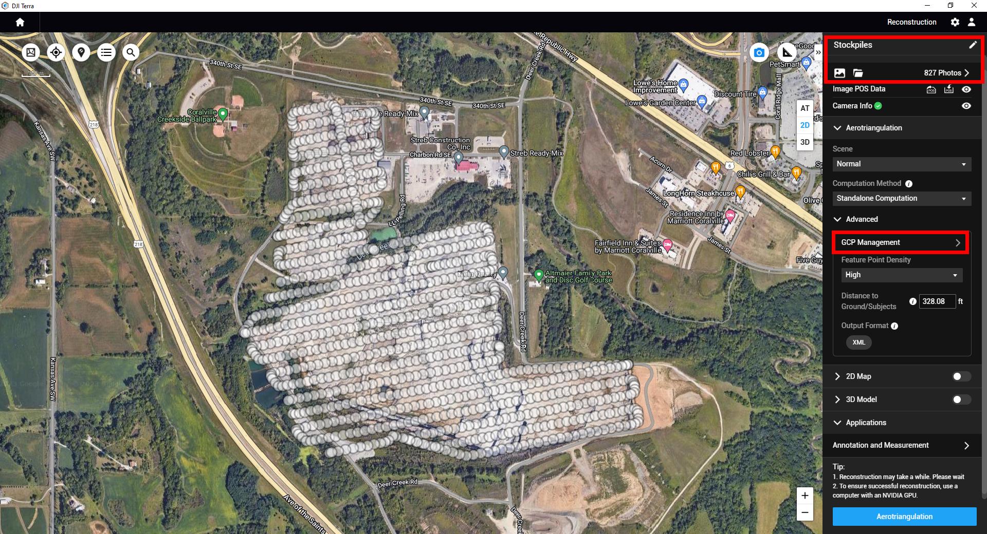
DJI’s quality-report guide distinguishes calibrated-image proportion, connected components, reprojection errors and georeferencing information. These describe different aspects of the reconstruction. A low reprojection error does not establish that a pile’s hidden base is correct, and a high image-use percentage can still leave a critical toe poorly reconstructed.
Inspect the mesh in top and oblique views for holes, floating objects, smoothed crests, distorted walls and gaps where material meets the ground. Check the orthomosaic for naming and footprint context. Use the point cloud for appropriate inspection and third-party export, but do not silently substitute a different surface representation for the accepted measurement.
DJI’s measurement FAQ specifically advises basing the volume on the reconstruction model rather than the point-cloud measurement when they disagree. Keep that distinction in the report.
7. Choose the pile boundary and defensible base
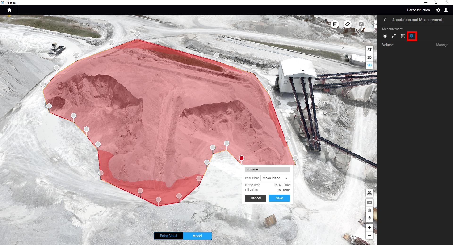
In Terra’s Annotation and Measurement page, use the 3D view and Volume tool. Add at least three points around the pile toe, finish the measurement with the current manual’s right-click procedure, choose the datum type, then name and save the result. The temporary single-measurement shortcut does not save an official annotation record.
The toe is where the material meets the underlying ground or floor. Trace that contact, including irregular indentations, rather than outlining the upper shoulder. Inspect vertices in 3D: a point accidentally placed on a wall, berm or pile face can change both the boundary and the fitted base.
Separate neighbouring piles with a documented convention where they merge. If the physical boundary is hidden, identify the shared-edge assumption and its reviewer. Do not present two visually convenient polygons as independently measured inventories when their separation is uncertain.
Terra offers two datum types. Mean Plane is a plane fitted from the measuring points; it can be inclined. Lowest Point is a horizontal plane through the lowest selected point. Mean Plane is not simply an average height, and neither option automatically recovers an irregular floor beneath the material.
Free-standing pile
Visible toe on a reasonably planar pad. Mean Plane can be a starting method after checking that the selected points represent the pad.
Sloping pad
A fitted plane may follow the slope. A horizontal lowest-point plane can include space beneath the pad and overstate the material.
Hidden or uneven floor
A wall or irregular base creates an assumption. Verify floor evidence or use an approved base-surface workflow; a plane cannot prove the hidden shape.
DJI’s older stockpile tutorial describes Lowest Point for selected wall or bunker situations. Treat that as a method to evaluate, not an automatic rule for every contained pile. Verify that the lowest selected point is on the actual floor and that the floor is acceptably horizontal. A drain, low outlier or hidden slope can make that assumption unsuitable.
For an uneven pad, preserve an accepted empty-pad survey, surveyed floor geometry or other defensible base evidence where available. If the task requires volume between two non-planar surfaces, use a workflow that explicitly supports that comparison and validate its import, alignment and calculation. Terra’s two annotation planes alone do not establish that capability.
Cut volume is the model above the chosen base; fill volume is below it. For a pile above a credible pad, cut is usually the inventory quantity of interest. Review unexpected fill instead of automatically subtracting it. Report which quantity is used and why; a net earthwork value and a stockpile inventory value are not interchangeable.
8. Decide whether the quantity is fit for use
Accept the dataset against the criteria agreed before capture. Evaluate geospatial accuracy, surface completeness and measurement assumptions separately. Checkpoints help test the first; visual surface review addresses the second; base evidence and boundary review address the third. None of these proves bulk density.
Keep the checkpoint discrepancies, point distribution and any rejected observations. Investigate a systematic vertical offset or unexplained outlier before quoting one favourable summary statistic. Do not delete an inconvenient point merely to make a report pass. Document a legitimate marking or survey error and retain the original record.
Ask a second operator to review a representative difficult polygon, especially at shared toes and walls. Differences can reveal an ambiguous convention rather than a software fault. Establish one approved interpretation and preserve the review history. This is a reproducibility check, not an independent certification of the true volume.
1,000 m² × 0.10 m = 100 m³
For a fixed 1,000 m² footprint, moving a planar base uniformly by 0.10 m changes the signed volume by 100 m³. Where the entire pile remains above both bases, raising the base removes that volume from the cut result. On an illustrative 2,000 m³ pile, that is 5%.
This is geometry, not a measured Matrice 4E error or guaranteed tolerance. It shows why a small base assumption can matter more than extra decimals in the software result.
Scroll within the table on a phone. Set project tolerances with the survey lead.
| Evidence | Accept when | Review or correct when |
|---|---|---|
| Capture | Critical images are sharp; the complete measured surface and toe are covered. | Blur, glare, missing faces or changing material affects the measured pile. |
| Position | Control basis is documented; independent checks meet the agreed project tolerance. | The reference system is uncertain, corrections failed or discrepancies remain unexplained. |
| Surface | The accepted mesh represents relevant crests, slopes and contact with the pad. | Holes, floating machinery or smoothed geometry affects the polygon. |
| Base | The selected method is supported by visible ground or accepted floor evidence. | Hidden toes, an uneven floor or a low outlier makes the plane speculative. |
| Record | Another reviewer can identify the polygon, base, version, units and exclusions. | The quantity cannot be reproduced from the saved project and report. |
Report a result as accepted, provisional or withheld with a reason. A provisional operational estimate can still be useful if its limits are explicit. It should not silently become a certified payment or accounting number later. Round the displayed result to a precision justified by the method and retain the underlying export for traceability.
9. Convert cubic metres to tonnes with approved density
The drone workflow estimates volume. Material mass needs bulk density, including the void spaces between particles, rather than the density of a solid mineral grain. Use a site-approved source appropriate to grading, moisture, compaction and the reporting purpose.
A generic gravel conversion factor can hide more uncertainty than the survey itself. Keep the measured cubic metres as a separate field even when a business report requires tonnes. Record who approved the density, its units, measurement or reconciliation date, and whether the estimate refers to wet or dry material.
2,000 m³ × 1.60 t/m³ = 3,200 t
If the same volume uses 1.50 or 1.70 t/m³, the estimate becomes 3,000 or 3,400 tonnes. The ±200-tonne change comes from the assumed density alone. These example densities are arbitrary teaching values, not tested values for a particular aggregate.
Where density comes from weighbridge reconciliation, compare equivalent material, time windows and storage conditions. Identify deliveries and removals between the weight record and survey, as well as moisture changes or contamination. A disagreement does not automatically prove that either the drone or scale is wrong; the two records may describe different quantities.
For silage, salt, soil, ore or other materials, apply the same discipline. A visible mound can be reconstructed while its composition, moisture or internal compaction remains unknown. Obtain appropriate material expertise when the mass estimate will drive a significant commercial decision.
10. Deliver a report that supports the next survey
Deliver the quantity together with the evidence needed to interpret it. A spreadsheet of pile names and numbers is insufficient when a reviewer cannot determine the capture time, floor method or excluded areas. Use a consistent report template and a persistent pile register.
Include an orthomosaic or site overview with IDs and polygons, a table of current volume and accepted previous volume, base-plane selection, cut and fill values, and the reviewer’s status. Add representative 3D views showing toes, walls and exceptions. Preserve the source project and quality report rather than embedding only a polished screenshot.
For downstream CAD or GIS use, agree on file type, reference system and units before capture. Terra’s visible-light outputs include LAS point-cloud options; orthomosaic delivery commonly uses TIFF. Confirm that the receiving application accepts the actual export and its coordinate metadata. A point cloud imported successfully does not prove that the receiving software used the same base or calculation.
- Identity
- Site, persistent pile ID, material, survey date and time, operator and reviewer.
- Acquisition
- Aircraft, route revision, camera settings, image count, positioning method and activity during capture.
- Coordinates + QA
- Reference system and units; control/checkpoint evidence; quality report; accepted surface and exceptions.
- Measurement
- Saved polygon or identifiable annotation, base method and supporting floor evidence, cut/fill results and reporting precision.
- Inventory
- Current and previous accepted m³; comparable-survey status; change in m³. Density source and tonnes estimate only when approved.
- Approval + archive
- Accepted, provisional or withheld status; reviewer, limitations, report revision and location of raw/project/export files.
Separate repeatability from change in stock
Keep the route, coordinate basis, camera treatment, processing parameters and base convention consistent where appropriate. The pile’s shape can change, so retrace the actual toe using the same interpretation rule rather than blindly reusing an old polygon. Record method changes that interrupt comparison.
Compute change as current accepted volume minus the comparable previous accepted volume. Do not describe that difference as production or sales unless movement records support the interpretation. Settlement, compaction, moisture effects, floor changes and different cut-off times can affect the comparison.
Distinguish separate pile inventories from surface-to-surface earthwork calculations. The latter requires aligned dated surfaces, a controlled comparison area and a supported analysis method. Use the mapping software resource when choosing the broader delivery and collaboration platform.
11. Troubleshoot the reason a pile is difficult
Hidden toe, bunker or adjacent material
Better imagery can reveal visible faces; it cannot photograph through the pile to recover an unknown floor. Obtain accepted base evidence, document the separation assumption or withhold the affected quantity. Do not choose Lowest Point solely because it produces a plausible inventory.
Uniform, wet or reflective surfaces
Weak texture, glare, standing water or snow can make image matching unreliable or represent a surface different from the intended material. Review images and mesh geometry, change the capture window or method, and recapture where needed. A larger file does not repair an unobserved surface.
Machinery, conveyors and moving material
Coordinate capture with site operations. If an object becomes part of the reconstructed surface, document how its area is excluded and whether material underneath remains unmeasured. Avoid editing a model to create a neat result without preserving the original evidence and approved method.
Vegetation or an uneven pad
Photogrammetry primarily observes visible surfaces. Ground classification may be useful where ground points exist, but it cannot establish every hidden floor or remove uncertainty under a covered pile. Assess a different measurement or base-survey method with the project lead.
Volume button unavailable or results disagree
Confirm that a suitable 3D reconstruction exists and the measurement is being made in the supported 3D view. Check the datum, vertices, units, saved annotation and surface representation. Follow current Terra documentation before assuming an orthomosaic or point-cloud view can supply the same measurement.
A complete report makes the assumptions visible enough for the next operator to challenge them.
12. Budget for the complete survey workflow
Start with the deliverable and control strategy, then price the equipment. SpeedyDrone’s live listings checked October 6, 2026 showed DJI Matrice 4E at CAD $6,164, D-RTK 3 at CAD $2,621, and DJI Terra Standard at CAD $2,634 for one year or $7,519 permanent. These are the listed item prices, not an all-inclusive deployed-system quote; confirm the selected licence and current offer.
A network correction service may suit a site without buying a local station. Where a station is needed, budget its setup, accessories and survey responsibility. Neither choice includes independent checkpoints automatically. Also allow for targets, survey equipment or qualified support, spare batteries, safe site setup and an archive process.

Size the processing and review work
Terra’s Windows workstation requirements and reconstruction resources depend on project size and selected outputs. Verify the current requirements before choosing hardware; do not turn a published minimum specification into a processing-time promise.
Budget operator training, Terra processing, survey review and report preparation as separate tasks. The person flying the route may not be the person qualified to approve its inventory result.
For recurring work, account for battery replacement, maintenance, insurance, site induction, licence administration and storage. Confirm who owns the raw data, who can change an accepted report, and how a corrected quantity reaches the inventory system. If procurement needs instalment planning, review SpeedyDrone’s financing information against the actual equipment proposal.
Browse the Matrice 4 Series collection for the relevant aircraft family. Avoid choosing a configuration solely from a headline flight time: the useful comparison is whether it can repeatedly deliver the accepted site dataset.
13. Plan Canadian flight and worksite permissions
The Matrice 4E is above 250 g. Canadian registration, pilot-certificate and operating requirements therefore need to be considered for the actual mission. Transport Canada distinguishes Basic, Advanced and Level 1 Complex operations; category depends on the operation, aircraft and applicable conditions, not on the fact that the job is called a stockpile survey.
Check airspace, aerodromes, people, site access and the relevant aircraft eligibility before flying. Controlled airspace or an operation outside ordinary VLOS conditions may need additional requirements or authorization. Do not infer permission for EVLOS or BVLOS from mapping automation, RTK, range specifications or a site owner’s approval.
Use Transport Canada’s current operating-category guidance and aircraft eligibility guidance for the specific operation. Separately coordinate blasting, cranes, conveyors, haul roads, exclusion areas and emergency procedures with the site supervisor.
Before capture
- Agree on pile IDs, cut-off time and report use.
- Confirm flight permissions and worksite controls.
- Set coordinates, correction source and independent checks.
- Identify hidden-base and shared-toe assumptions.
Before departure
- Review sharpness, positioning and complete toe coverage.
- Confirm targets and acquisition files.
- Log moving material and weather exceptions.
- Recapture critical missing or changed areas.
Before release
- Check the accepted metric surface and independent evidence.
- Save base, polygon, units and cut/fill results.
- Approve density separately when tonnes are needed.
- Archive evidence and record the reviewer’s status.
Frequently asked questions
Can Matrice 4E and Terra measure stockpile volume?
Yes. Matrice 4E captures photogrammetric imagery and Terra measures a saved polygon on a reconstructed 3D model relative to a selected base plane. The result depends on capture, control, surface quality, boundary and base evidence. It is not a guaranteed accuracy percentage for every pile.
Do I still need checkpoints when flying with RTK?
Use independent checkpoints when the result needs verification. RTK helps position images, while checkpoints test the reconstruction without constraining it. Their distribution, survey method and tolerance should follow the project requirements. RTK status alone does not validate the hidden floor or density.
Should I use Mean Plane or Lowest Point?
Mean Plane fits a potentially inclined plane through the selected measuring points. Lowest Point uses a horizontal plane through the lowest selected point. Choose the method supported by the pad or floor evidence. An uneven or hidden base may require a different approved base-surface workflow.
Why do point-cloud and model volumes differ?
They represent the surface differently and can respond differently to sampling and geometry. DJI’s measurement FAQ advises using the reconstruction-model measurement when those results disagree. Confirm that the boundary, base, units and accepted surface are the same before comparing exported results.
Does a 2 cm GSD mean 2 cm survey accuracy?
No. GSD describes image sampling on the surface, not the complete positional or volume uncertainty. Independently measured checks, surface inspection and base review are needed to assess the actual dataset. Do not quote pixel size as a guaranteed inventory tolerance.
Can I convert the volume directly to tonnes?
Only with a documented, approved bulk-density value appropriate to the material and reporting conditions. Multiply m³ by t/m³ to estimate tonnes, retain the original volume, and state the density source and wet or dry basis. Example internet densities are not audited material evidence.
Can Terra compare this month’s stockpile with last month’s?
You can compare accepted, separately recorded pile volumes when coordinate basis, measurement conventions and capture timing are compatible. A numerical difference is not automatically production or sales. A separate surface-to-surface earthwork analysis needs an explicitly supported and validated comparison workflow.
Which Terra licence should a stockpile team start with?
Terra Standard includes the visible-light reconstruction and measurement functions relevant to this workflow in DJI’s current feature list. Verify the exact licence, activation arrangement, workstation and required exports against a representative dataset before purchase. Extra rendering features do not fix uncertain geometry.
Primary references
Manufacturer tutorials illustrate methods; project tolerances and acceptance belong to the site’s approved procedure. Source pages and offers were checked October 6, 2026.
Plan a stockpile workflow for your site
Send SpeedyDrone your site size, material types, survey frequency and intended report use. Include correction coverage, base-survey evidence and required CAD or GIS outputs so the equipment discussion starts with the quantity you need to deliver.


