


Wildfire Detection and Incident Support with DJI Enterprise Drones in Canada
DJI Enterprise drones can provide thermal and visible intelligence before, during and after a wildfire - but only when the operation is authorized and integrated into the wildfire aviation plan. Unauthorized drones can ground tankers and helicopters, delay suppression and put crews at immediate risk.

H30T combines native 1280 x 1024 thermal capture, 34x optical visible zoom, night imaging and a 3,000-metre laser rangefinder for Matrice 400 and other supported enterprise platforms.
The wildfire airspace is closed unless the response authority brings you into the operation.
Canadian Aviation Regulations automatically restrict aircraft, including drones, over a wildfire and within 5 nautical miles at less than 3,000 feet above ground level. A NOTAM is not required for that restriction to exist. Authorized wildfire-response RPAS must operate under the appropriate fire control authority and coordinated aviation plan.
| Situation | May the drone launch? | Required action |
|---|---|---|
| Public, media or contractor wants wildfire footage | No Unauthorized | Stay outside the restriction and do not interfere with emergency operations |
| Utility or municipality sees a heat or smoke anomaly before an incident is declared | Only under its normal approved operation and from a legal location | Report the suspected wildfire and do not continue toward smoke or fire without authorization |
| Fire authority requests RPAS support | Potentially yes | Integrate with incident command, air operations, NOTAMs, crewed aircraft and the assigned sector |
| Crewed aircraft arrive unexpectedly | Suspend or terminate the drone operation | Yield immediately and exit the airspace by the quickest safe means |
| Prescribed burn uses an assigned UAV resource | Yes when included in the approved burn and aviation plan | Maintain segregated or coordinated airspace and follow the responsible authority's tasking |
| Post-fire area remains an active emergency site | Only with authority | Confirm incident status, restricted area, hazards and demobilization before launching |
Use different drone workflows before, during and after the incident.
Detection does not mean flying toward an active fire without permission. Before an incident, approved patrols may monitor high-risk assets. Once fire response begins, the RPAS becomes an assigned aviation resource inside the incident command structure.
Pre-position detection and patrol.
- Patrol utility, industrial, municipal and forestry assets before an incident exists.
- Compare visible and thermal conditions against a documented baseline.
- Use scheduled routes only within the approved operating category.
- Create an escalation path from anomaly to human confirmation and wildfire reporting.
- Do not dispatch toward smoke or fire without fire-control authorization.
Confirm location and visible threat from a legal position.
- Report the suspected wildfire to the responsible provincial or territorial agency.
- Remain outside the automatic wildfire restriction unless authorized.
- Provide visible context, smoke column, fuel, nearby structures and access information.
- Treat thermal anomalies as leads rather than final fire classification.
- Transfer authority to incident command when response begins.
Support incident command and ground crews.
- Map fire edge, spot fires, hotspots and threatened values.
- Provide coordinates for crew verification and resource assignment.
- Monitor containment lines, structure protection and tactical progress.
- Share live visible and thermal information under the aviation plan.
- Yield immediately to crewed aircraft and assigned wildfire aviation resources.
Locate residual heat and reduce re-ignition risk.
- Scan containment edges, ash pits, roots, slash and structure debris.
- Revisit geolocated hotspots after ground crews take action.
- Document confidence, target size and any canopy or smoke limitation.
- Use consistent altitude, palette and gain for comparisons.
- Do not direct crews into unstable or hazardous terrain without safety review.
Document impact and recovery.
- Create visible records of burned area, infrastructure and access routes.
- Support damage assessment, utility inspection and restoration planning.
- Compare pre- and post-event imagery where approved.
- Separate operational records from public-communications imagery.
- Preserve metadata, coordinates and chain-of-custody requirements.
Integrate authorized UAV resources into the burn plan.
- Use segregated or coordinated airspace established by the responsible authority.
- Support ignition, perimeter monitoring or hotspot checks only as assigned.
- Brief manned aircraft, ground ignition teams and safety staff.
- Define launch, recovery, lost-link and emergency landing areas.
- Keep public and unauthorized aircraft outside the operational area.
Thermal, visible zoom, coordinates and live command serve different decisions.
A useful wildfire drone system must do more than show a colourful thermal image. It should help command identify the location, understand the visible context, assign verification and preserve a time-stamped record.
Native radiometric thermal detail for high-performance missions.
Native detector with supported 1280 x 1024 Super Resolution output.
Manufacturer-rated no-wind maximum carrying H30T.
Remote operations platform requiring approved routes and escalation.
| Capability | Operational use | Key limitation |
|---|---|---|
| Thermal hotspot scan | Locate surface heat, residual hotspots, spot fires and heat around structures | Canopy, terrain, smoke, distance and false positives can hide or imitate targets |
| Visible wide camera | Show smoke, terrain, access, structures, crews and fire behaviour context | Smoke, darkness, glare and distance can reduce useful detail |
| Visible telephoto | Inspect distant flame fronts, structures, line conditions and access hazards | Long zoom magnifies vibration and atmospheric distortion |
| Laser rangefinder | Support coordinates and distance for observed targets | Rain, fog, target reflectivity and incidence angle affect performance |
| NIR and night imaging | Improve visible-light context during authorized low-light operations | NIR is not thermal illumination and does not remove obstacle risk |
| FlightHub 2 livestream | Share current imagery with authorized command and specialists | Bandwidth, roles, retention and viewer count must be managed |
| Live annotations | Mark hotspots, routes, exclusion zones and task sectors | Annotations require naming, coordinate and close-out standards |
| Change detection | Compare patrol areas, fire impact or post-event conditions | Lighting, smoke, capture geometry and time differences can create false change |
Portable response, high-performance overwatch and remote patrol are different systems.
Choose the platform around launch speed, thermal detail, visible stand-off, weather protection, mission duration, automation, transport, aviation approval and data policy.
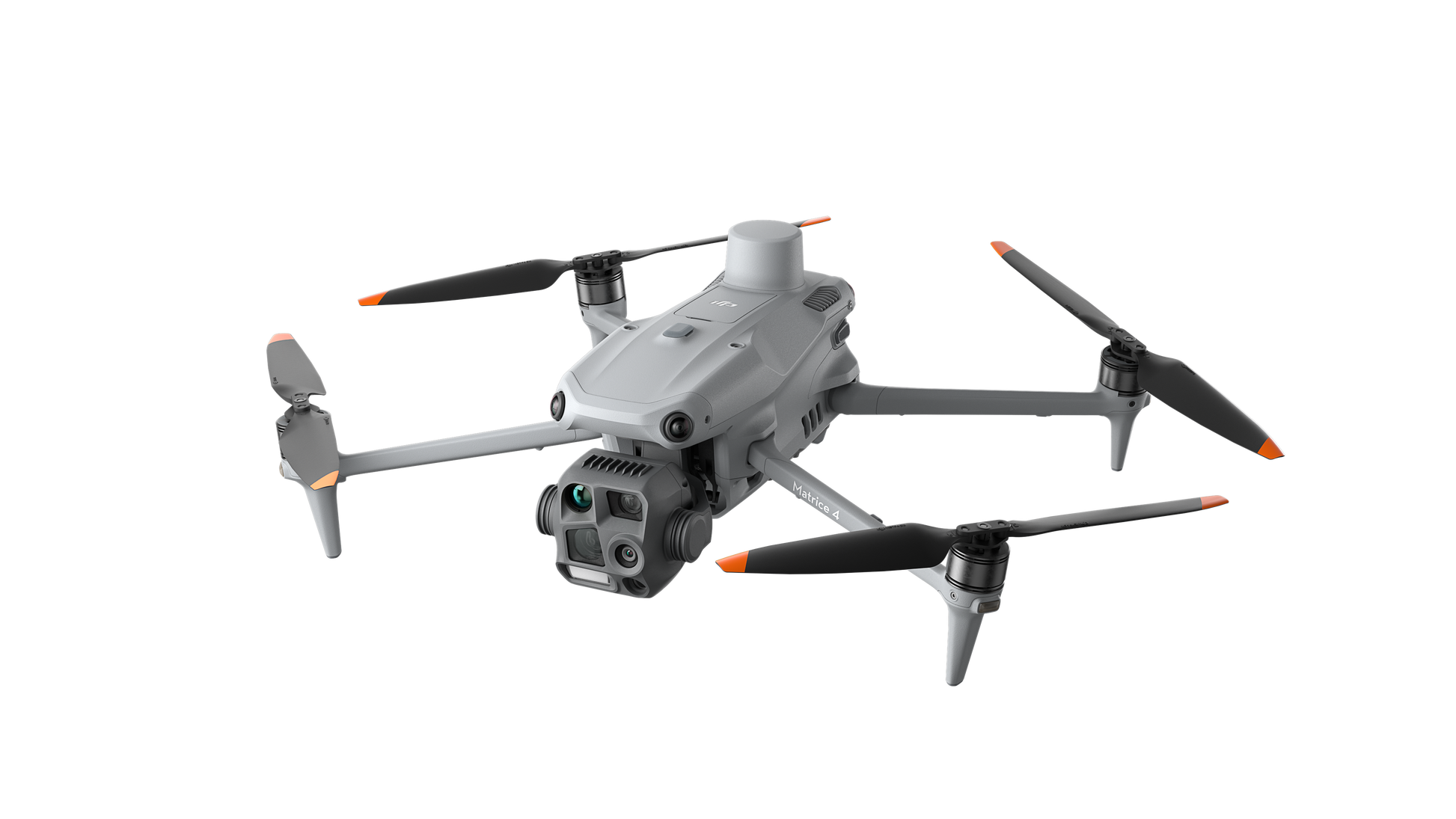
DJI Matrice 4T
Compact thermal response, visible zoom, NIR and laser rangefinding.
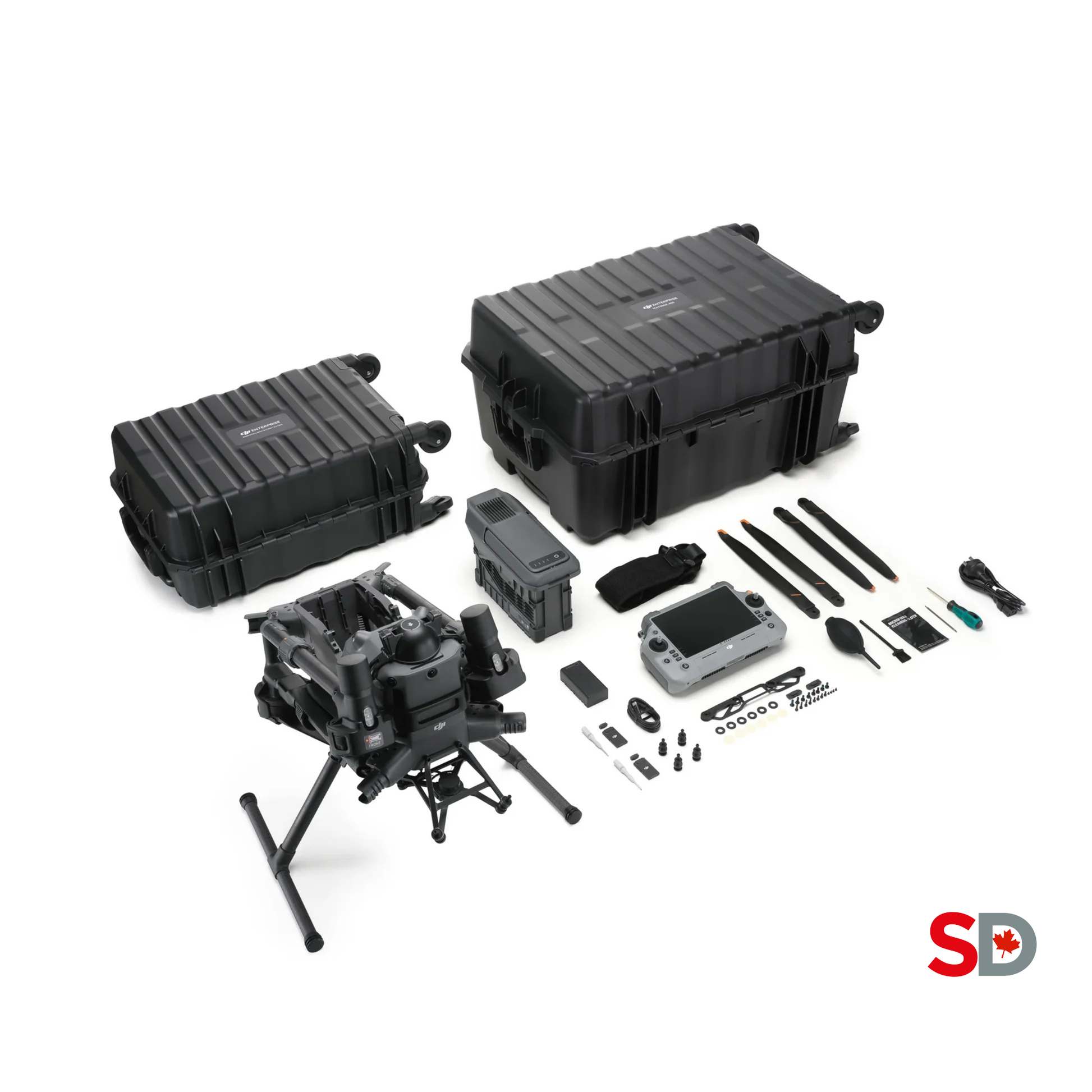
DJI Matrice 400
Long-duty modular aircraft with IP55 protection and H30T support.
DJI Zenmuse H30T
Native 1280 x 1024 thermal, 34x optical zoom and 3,000 m laser.

DJI Dock 3
Remote scheduled and dispatched operation with Matrice 4D Series.
| Specification | Matrice 4T | Matrice 400 + H30T | Dock 3 + Matrice 4TD |
|---|---|---|---|
| Primary role | Portable rapid incident support | High-performance thermal and visible overwatch | Remote patrol, detection and repeated site coverage |
| Native thermal detector | 640 x 512 | 1280 x 1024 | 640 x 512 |
| High-resolution thermal output | 1280 x 1024 Super Resolution under supported conditions | Native 1280 x 1024 | 1280 x 1024 UHR output under supported conditions |
| Thermal digital zoom | 28x | 32x equivalent | 28x |
| Visible long-range camera | 168 mm tele camera with hybrid zoom workflow | 34x optical and up to 400x digital zoom | 168 mm tele camera with up to 112x hybrid zoom |
| Laser rangefinder | Up to 1,800 m under stated tests | Up to 3,000 m under stated tests | Up to 1,800 m under stated tests |
| Manufacturer-rated flight time | Up to 49 minutes | Up to 59 minutes carrying H30T | Up to 54 minutes |
| Ingress protection | Confirm operating limits; not positioned as the dock-rated weather platform | M400 IP55 and H30T IP54 under stated conditions | Dock IP56 and aircraft IP55 under stated conditions |
| Operating model | Mobile crew with DJI RC Plus 2 Enterprise | Mobile heavy-enterprise crew with modular payload | Fixed or vehicle-mounted dock with FlightHub 2 |
| Best fit | Fire departments and emergency teams needing portability | Provincial, utility, industrial and high-consequence programs | Approved recurring patrol and remote response around fixed assets |
A sixteen-step process from authority to after-action review.
The drone should enter the incident as a tasked resource, not as an independent information stream. Every observation should have an owner, coordinate, confidence level and close-out status.
Define jurisdiction and authority
Identify the responsible fire-control agency, incident commander, aviation authority, property owner and RPAS approval path.
Confirm the mission
Detection patrol, report confirmation, hotspot mapping, structure protection, mop-up, post-fire documentation or prescribed-burn support.
Review wildfire airspace
Check the automatic 5 NM restriction, current NOTAMs, controlled airspace, temporary restrictions, water-bomber routes and nearby bases.
Assign air-operations coordination
Name who can authorize launch, coordinate with crewed aircraft, suspend the drone and close the RPAS mission.
Brief the crew
Pilot, visual observer, payload operator, air-operations contact, GIS or data lead and incident-command liaison.
Select launch and recovery zones
Choose areas outside smoke, flame, falling trees, apparatus routes, water-bomber approaches, public traffic and evacuation movement.
Configure the sensor
Select thermal gain, palette, isotherm or alert settings, visible zoom, NIR, recording, coordinate display and laser workflow.
Launch under positive control
Confirm communication, manned-aircraft status, NOTAM review, home point, RTH, battery reserve and emergency actions.
Scan systematically
Use agreed sectors, altitude bands, overlapping passes and visible-thermal correlation rather than random searching.
Mark and classify leads
Assign hotspot IDs, coordinates, time, confidence, image reference, access notes and possible false-positive sources.
Share with command
Use approved radio, map, FlightHub 2 annotation, livestream or incident data system without bypassing command structure.
Support ground verification
Guide crews only through the incident command process and record whether each lead was confirmed, cleared or inaccessible.
Deconflict continuously
Monitor crewed aircraft, radio calls, route changes, smoke, wind, visibility and battery; land if safe separation is uncertain.
Close and document
Upload approved media, export logs, preserve records, report incidents and complete the post-flight inspection.
After-action review
Compare mission objective, decisions supported, missed areas, false positives, communication delays and corrective actions.
Update the SOP
Revise route templates, crew qualifications, data settings, checklists and procurement requirements before the next deployment.
Separate authority, aviation, flight, sensor and data responsibilities.
Wildfire operations move quickly. Clear roles prevent a thermal lead from bypassing command, prevent two aircraft from assuming the same airspace, and preserve a usable incident record.
Defines operational priority.
Approves the drone mission objective, receives results and decides how intelligence changes response.
Controls the aviation picture.
Coordinates crewed and remotely piloted aircraft, launch windows, altitudes, sectors and suspension criteria.
Owns the drone operating capability.
Maintains pilots, aircraft, SOPs, readiness, records, vendor support and program changes.
Owns the safe flight.
Confirms legality, aircraft status, launch decision, airspace separation, emergency response and landing.
Protects the local airspace and site.
Scans for aircraft, smoke, trees, apparatus, people, wires, terrain and changing hazards.
Owns the sensor search.
Manages thermal gain, visible zoom, recording, hotspot IDs, coordinates and image quality.
Turns observations into usable intelligence.
Maintains layers, coordinate standards, annotations, exports, access controls and the incident record.
Challenges unsafe assumptions.
Reviews crew fatigue, smoke, heat, falling trees, battery handling, launch zones and public interaction.
Protects accuracy and trust.
Separates verified incident information from internal leads and ensures public imagery does not expose sensitive operations.
The drone supports the air attack only when it remains inside positive control.
Tankers and helicopters can arrive low, operate through smoke, collect water nearby and use operational frequencies that a drone team may not monitor. The RPAS must be assigned, visible to air operations and ready to land without delay.
| Control | Required municipal or agency practice |
|---|---|
| Authority to launch | Identify the fire-control and incident role that can approve the RPAS mission |
| Air-operations contact | Maintain a direct and tested communication path to the aviation coordinator |
| NOTAM review | Check current notices before launch and monitor for changes throughout the mission |
| Sector and altitude | Use an assigned operating area and altitude rather than free-ranging around the fire |
| Crewed aircraft priority | Give way immediately; suspend and land whenever separation is uncertain |
| Water pickup areas | Remain clear of lakes, rivers and approach paths used by water bombers and helicopters |
| Smoke visibility | Do not rely on visual detection of aircraft through smoke; use positive coordination |
| Launch site | Protect the drone crew from apparatus, evacuation traffic, falling trees, ash pits and flame movement |
| Lost link | Use an incident-specific action that will not climb into crewed-aircraft altitude or cross active sectors |
| Mission suspension | Define clear triggers for aircraft arrival, communication failure, wind, smoke, battery, fatigue or route change |
Thermal intelligence is powerful because it is interpreted, not because it is automatic.
A wildfire camera sees infrared radiation from visible surfaces. It does not see through a ridge, guarantee a hotspot under canopy or turn an apparent temperature into a confirmed tactical hazard.
Thermal can outperform visible imaging, but it is not unaffected.
Dense smoke, humidity, long distance and hot air can reduce contrast and distort apparent temperature.
A thermal camera cannot see through solid cover.
Tree crowns, ridges, buildings and terrain can hide ground fire or hotspots from the aircraft's line of sight.
Not every hot object is wildfire activity.
Sun-heated rock, vehicles, exhaust, industrial equipment, reflective water and recently burned ground can imitate targets.
Detection falls when the hotspot occupies too few pixels.
Altitude, stand-off, native resolution, lens, focus and target size control whether a thermal pattern is usable.
Radiometric values depend on the complete setup.
Emissivity, reflection, humidity, distance, angle, gain, filter and calibration influence measured values.
The scene can change faster than the scan.
Spotting, smoke direction, flame front and access hazards can move while the aircraft is completing a route.
A coordinate without context is not an operational handoff.
Create a repeatable hotspot record that helps command decide whether to assign a crew, re-task the aircraft, mark the location for mop-up or clear the observation as a false positive.
| Hotspot field | Required content |
|---|---|
| Hotspot ID | Unique incident and sequence identifier, such as WF26-A-014 |
| Time | Local time with time zone and image or video timestamp |
| Coordinate | Approved incident coordinate format and datum |
| Sensor | Aircraft, thermal channel, visible channel, gain, zoom and relevant mode |
| Target description | Estimated size, shape, pattern, fuel or structure context and visible smoke or flame |
| Confidence | High, medium or low with a reason and known false-positive factors |
| Access and hazards | Slope, trees, power lines, ash, roads, water, smoke and crew approach limitations |
| Command action | Monitor, re-scan, assign crew, mark for mop-up, verify by another aircraft or clear |
| Close-out | Confirmed fire, residual heat, false positive, inaccessible or unresolved |
Share live intelligence without creating an uncontrolled audience.
FlightHub 2 can connect mobile aircraft, Matrice 400, Dock 3 and H30T workflows through remote control, livestreaming, map annotations, task routes, media review and integrations. The incident must still define access and record ownership.
Use the platform to coordinate the mission.
- Share authorized live visible and thermal feeds.
- Display simultaneous livestreams from multiple devices.
- Place hotspot, fire-edge, exclusion-zone and route annotations.
- Assign task areas and synchronize changes across users.
- Compare imagery or orthomosaics from different times.
- Export flight records and approved media for the incident file.
Decide cloud, on-premises and retention before fire season.
- Define roles, least privilege, MFA and administrator access.
- Identify who can livestream, record, download or share links.
- Classify locations, infrastructure, personnel and incident imagery.
- Set retention, legal hold, disclosure and offboarding procedures.
- Review cloud location, contracts, subprocessors and integrations.
- Evaluate FlightHub 2 On-Premises or AIO where policy requires local control.
Provincial policy can affect whether a DJI system is eligible for a government buyer.
Ontario announced restrictions in May 2026 on provincial government and Ontario Provincial Police use and future procurement of Chinese-made drones, beginning with highly sensitive OPP operations and work toward a broader government phase-out.
| Buyer | Required procurement action |
|---|---|
| Ontario provincial ministry or agency | Confirm current provincial restrictions, approved jurisdictions, transition plan and exceptions before specifying DJI |
| Ontario Provincial Police or highly sensitive operation | Apply the current OPP and provincial security direction; do not assume DJI eligibility |
| Ontario municipality or broader public-sector buyer | Review Buy Ontario requirements, municipal policy, cybersecurity and whether additional restrictions have been issued |
| Other province or territory | Confirm its current procurement, security, data-residency and approved-vendor requirements |
| Private utility or industrial operator | Apply corporate security, critical-infrastructure, insurer, customer and regulator requirements |
Train the team for wildfire aviation, not only for normal drone flight.
A technically skilled pilot can still create risk if the crew does not understand wildfire aviation, incident command, thermal limitations, fatigue, smoke and emergency-site coordination.
Build beyond the legal minimum.
Use certificates that match the operation and train pilots for night, terrain, smoke, public safety and emergency decision-making.
Understand the crewed-aircraft environment.
Train on tankers, helicopters, water pickup areas, air-operations roles, NOTAMs, right-of-way and immediate suspension.
Find leads without overclaiming.
Cover palettes, gain, isotherms, resolution, false positives, atmospheric effects and ground verification.
Integrate into the response structure.
Define request, approval, tasking, reporting, safety, communications, demobilization and after-action review.
Operate the shared information workflow.
Train roles, permissions, livestream, annotations, exports, retention, MFA, incident records and offboarding.
Practice before fire season.
Run tabletop and field exercises for aircraft conflict, lost link, hotspot handoff, false detection and communications failure.
Write the launch, airspace, sensor, data and close-out process before the incident.
The checklist should fit the agency's jurisdiction, aircraft, certificate, fire-control authority, incident-command system and data environment. It should be short enough to use under pressure.
Price the aircraft, integration, training and annual readiness together.
Public prices below were checked July 21, 2026. Taxes, care, batteries, software, communications, insurance, installation, qualification, vehicles and incident integration are additional.
Matrice 4T Response Edition
- Three-battery SpeedyDrone package.
- Thermal, wide, medium-tele and tele cameras.
- NIR light and laser rangefinder.
- AS1 speaker and AL1 spotlight included in the current package.
- Best for mobile fire, emergency-management and municipal teams.
Matrice 400 + H30T
- Matrice 400 Full Package at CAD 14,099.
- Zenmuse H30T at CAD 12,810.
- Native 1280 x 1024 thermal capture.
- 34x optical visible zoom and 3,000 m laser rangefinder.
- Best for high-consequence wildfire, utility and public-safety programs.
Dock 3 + Matrice 4TD
- Dock 3 at CAD 21,509.
- Matrice 4TD at CAD 11,628.
- Dock IP56 and aircraft IP55 under stated conditions.
- Scheduled patrol, remote dispatch and FlightHub 2 integration.
- Installation, power, network, software and authorization are additional.
| Program model | First-year planning range | Typical additions beyond public hardware |
|---|---|---|
| Portable Matrice 4T response team | CAD 15,000-25,000 | Training, insurance, batteries, cases, communications, thermal workflow, SOPs and FlightHub resources |
| Matrice 400 + H30T high-performance team | CAD 38,000-60,000 | Additional TB100 batteries, care, training, data, vehicle setup, communications and maintenance reserve |
| Dock 3 + Matrice 4TD remote patrol | CAD 45,000-100,000+ | Power, network, site engineering, mounting, FlightHub, cybersecurity, commissioning and remote-operation approval |
| Multi-agency regional program | Project-specific | Shared governance, multiple crews, interoperable communications, on-premises data, exercises and support contracts |
Choose the system from the authorized mission and command workflow.
A fire department may need rapid portable launch. A utility may need pre-incident patrol around fixed assets. A provincial wildfire program may need native thermal detail, long endurance and a more formal aviation system.
Portable incident support.
- Fire department or municipal response.
- Fast vehicle deployment.
- Thermal and visible context in one aircraft.
- Moderate area and mission duration.
- Lower acquisition cost than the heavy platform.
High-consequence wildfire intelligence.
- Native 1280 x 1024 thermal requirement.
- Long visible stand-off and laser range.
- Large or complex incident areas.
- Utility, provincial or industrial public-safety programs.
- Shared modular enterprise fleet.
Approved recurring patrol and remote readiness.
- Fixed high-risk property or utility corridor.
- Reliable power, network and maintenance access.
- Established detection and escalation logic.
- Approved remote operating category.
- Proven mobile and FlightHub workflow.
Canadian airspace, thermal, platform and incident questions answered.
Can anyone fly a drone near a wildfire in Canada?
No. Unauthorized drone operations over a wildfire or within 5 nautical miles, approximately 9.3 kilometres, at less than 3,000 feet above ground level are prohibited. The restriction applies automatically and does not require a NOTAM. Only aircraft directly involved in wildfire response and authorized by the appropriate fire control authority may enter the restricted area.
Can an authorized fire department use a drone during an active wildfire?
Yes, but the drone operation must be integrated into the incident command and aviation plan. The appropriate fire control authority must authorize access, manned-aircraft operations must be deconflicted, current NOTAMs must be reviewed, crew communication must be defined and the drone must land immediately if safe separation cannot be maintained.
What can a thermal drone detect during a wildfire?
A thermal drone can identify surface heat patterns that may be consistent with active flame, hot ground, burning vegetation, residual hotspots, spot fires, heat around structures or changing fire edges. It cannot see through solid terrain or dense canopy, and smoke, distance, humidity, target size, emissivity and viewing angle can affect the image.
Which DJI drone is best for rapid wildfire incident support?
DJI Matrice 4T Response Edition is the strongest compact current option in this guide. It combines a native 640 by 512 thermal detector, Super Resolution output, three visible cameras, NIR illumination, laser rangefinding and a portable three-battery field package.
When is Matrice 400 with H30T the better choice?
Choose Matrice 400 with H30T when the team needs native 1280 by 1024 thermal detail, stronger visible optical zoom, a 3,000-metre laser rangefinder, longer manufacturer-rated endurance, IP-rated enterprise hardware, payload flexibility or a shared platform for high-consequence public-safety and inspection missions.
Can DJI Dock 3 automatically patrol for wildfire hotspots?
Dock 3 and Matrice 4TD can support scheduled patrols, remote dispatch and infrared temperature-anomaly alerts through FlightHub 2. This is not automatic permission to enter wildfire-restricted airspace, and it is not a certified guarantee of wildfire detection. Every route, alert, deployment and incident transition requires an approved operating and escalation plan.
Can wildfire drones operate at night?
Night operations may be useful for thermal contrast and reduced visible smoke glare, but they require a legal operating category, trained crew, night procedures, suitable aircraft configuration, obstacle and terrain planning, lighting where required and direct coordination with wildfire aviation management.
Can drones replace crewed wildfire aircraft?
No. Drones are a situational-awareness tool. Crewed aircraft remain essential for water and retardant delivery, crew transport, logistics, patrol, infrared scanning and other response functions. Drone operations must support rather than disrupt the coordinated aviation plan.
Can FlightHub 2 share wildfire imagery with incident command?
FlightHub 2 supports livestreaming, simultaneous video, live map annotations, route assignment, media review and organization-level roles. Agencies should establish who may view, record, export and retain incident data before deployment.
What Canadian pilot certificate is required?
The required certificate depends on aircraft weight, airspace, people proximity, visual-line-of-sight method and the operation. Many public-safety teams use Advanced-certified pilots as a practical baseline. Lower-risk BVLOS operations require Level 1 Complex certification and operation under an RPOC, while operations outside standard categories may require an SFOC-RPAS.
How much does a wildfire drone program cost in Canada?
Public SpeedyDrone prices checked July 21, 2026 listed Matrice 4T at CAD 9,439, Matrice 4T Response Edition at CAD 10,699, Matrice 400 Full Package at CAD 14,099, Zenmuse H30T at CAD 12,810, Dock 3 at CAD 21,509 and Matrice 4TD at CAD 11,628. Training, batteries, software, insurance, installation, communications and incident integration are additional.
Does Ontario currently restrict government use of Chinese-made drones?
Ontario announced restrictions in May 2026 on provincial government and Ontario Provincial Police use and procurement of Chinese-made drones, beginning with highly sensitive OPP operations and work toward a broader phase-out. The announcement also states that the Buy Ontario Act applies to public-sector organizations, including municipalities. Every Ontario buyer should obtain current procurement and legal guidance rather than assuming eligibility.
What should a wildfire drone SOP include?
The SOP should cover authority to launch, incident-command integration, air-operations coordination, NOTAM review, crew roles, communications, manned-aircraft conflict response, launch and recovery zones, thermal scan method, hotspot handoff, data retention, emergency procedures, battery rotation, maintenance, public information and after-action review.
How should hotspot coordinates be reported?
Use the incident's approved coordinate system and naming convention. Include the time, aircraft, sensor, image or video reference, coordinate, estimated hotspot size, confidence, visible context, access hazards and whether a ground team confirmed the finding. Avoid sending an isolated map pin without operational context.
Verify the fire-control authority, NOTAM, operating category and procurement policy.
Build the wildfire RPAS program around authorization, aviation and incident command.
Send the province, agency, mission phase, fire-control authority, expected airspace, current certificates, thermal requirement, incident-command workflow, data policy, number of crews, annual exercises and whether the team needs a demonstration, equipment quote, training, financing, FlightHub review or phased deployment assessment.


