


Enterprise workflow resource
DJI Terra can reconstruct a 3D model from qualifying drone video by extracting still frames first. The useful question is whether those frames support the model—and the decision—you need.
Start with the original recording and its flight data. Confirm that Terra can read the source, inspect the extracted images, run a representative pilot project, then assess the geometry and any required measurement accuracy. A successful import is only the first of those checks.
Technical references checked October 7, 2026 · Video import introduced in Terra v5.3.0 · Guidance below separates DJI requirements from recommended team practices.
In this resource
- Check the source video
- Confirm licence and workstation
- Extract frames and run a pilot
- Inspect coverage and geometry
- Troubleshoot by error code
- Choose video or planned photos
- Validate, restrict or re-fly
- Use archives and emergency footage
- Prepare the handoff record
- Plan software and acquisition
- Frequently asked questions
- DJI primary references
01 — Check whether the source video qualifies
The current DJI Terra data-import manual lists .mp4 and .ts video inputs. It names Mavic 3T, Mavic 3E, Matrice 4E, Matrice 4T, Matrice 4D and Matrice 4TD as supported video-source aircraft. This is a documented model list, not a promise that every recording from those aircraft is suitable.
DJI's feature announcement requires GPS metadata. A filename ending in MP4 does not establish that the required flight data survived. A downloaded social clip, screen recording, edited compilation or third-party camera file should not be treated as equivalent to the original aircraft recording.
Keep the original video and matching flight data together
For missing-metadata error 1033, DJI specifically instructs users to check for a same-name .SRT flight-data file in the same directory. If it is missing, recover the complete original video and its matching SRT from the aircraft or SD card. Keep the original base filenames aligned; do not pair a clip with flight data from another recording.
Work from a processing copy and retain an untouched archive. Before importing, play the entire recording, check that the file size is plausible and note where it came from. DJI's troubleshooting guidance warns against third-party compression, transcoding or trimming of the original video. Select the useful segment inside Terra instead.
GPS can also be genuinely absent or unreliable during capture. DJI identifies prolonged GPS-loss environments, including tunnels, indoor scenes and obstructed areas, as unsuitable for this workflow. Recovering a missing companion file may fix an export problem; it cannot recover measurements that were never recorded.
Three separate gates before a model becomes a deliverable
- Source eligibilitySupported recording, readable original file and usable flight metadata.Can Terra use this input?
- Reconstruction qualitySharp frames, connected views and coverage of the required surfaces.Did the geometry reconstruct?
- Fitness for purposeDeclared use, independent checks where needed and documented limits.Can the client rely on it?
02 — Confirm the edition and processing environment
Separate video import from the reconstruction output you want. DJI's current edition comparison lists video import across the editions in its detailed table. Standard supports visible-light mesh reconstruction and DSM/DOM outputs. Gaussian splatting is listed for Flagship and Cluster, not Standard. Ordinary video-derived mesh reconstruction therefore should not be sold as requiring Flagship solely because the source is video.
The import manual also says extracted frames can enter aerotriangulation, 2D, 3D and Gaussian reconstruction. That describes available downstream workflows, not a guarantee that a particular clip has appropriate coverage or that your licence enables every output. For a 2D map, for example, an oblique orbit may leave ground hidden even if it produces a recognizable building model.
Before committing a full archive, record the installed version, activated edition, desired output and project location. DJI's release notes place video import in v5.3.0, released July 23, 2026; the reviewed downloads and release notes show v5.3.5 dated August 20. Check the current installation rather than assuming an older workstation has the feature.
Workstation baseline from DJI's current manual. On a narrow screen, scroll within the table.
| Component | Documented baseline | Planning implication |
|---|---|---|
| Operating system | Windows 10 or later, 64-bit | Check the actual processing computer, not the field laptop's brand. |
| CPU and GPU | Intel Core i5 or later; NVIDIA GPU with compute capability 6.1 or higher | Verify the GPU model and driver. A newer non-NVIDIA GPU is not an equivalent documented configuration. |
| VRAM and RAM | At least 4 GB VRAM and 32 GB RAM | Available RAM after other applications matters. Baseline compliance is not a dataset-size guarantee. |
| Storage | At least 200 GB available; an SSD with that free space is recommended | Budget for source footage, extracted images, cache and outputs—not only the original video. |
These are configuration requirements, not a processing-time estimate. A short clip can contain many redundant frames, while a longer clip can contain little usable geometry. Start with a representative segment and observe the actual extracted image count and project resource use. The configuration manual is the appropriate reference when sizing a workstation.
A repeatable first run
03 — Extract frames, then test the reconstruction
The workflow is still photogrammetry: Terra selects still images from a video and uses those images for reconstruction. It does not make a reliable model merely by replaying a clip. The following recipe combines DJI's documented controls with a recommended small-project test before larger processing.
-
Define the required output
Write down the target area, surfaces that must be visible and intended use. “A scene model for orientation” and “a model for checking a clearance” need different acceptance evidence. Identify the receiving viewer or GIS application before choosing output formats.
-
Create a visible-light project and import the source
Use Terra's video selection control with the original compatible recording and matching flight data. Keep a record of the project name and storage path. If import fails, capture the error code and use the troubleshooting table below before changing the source.
-
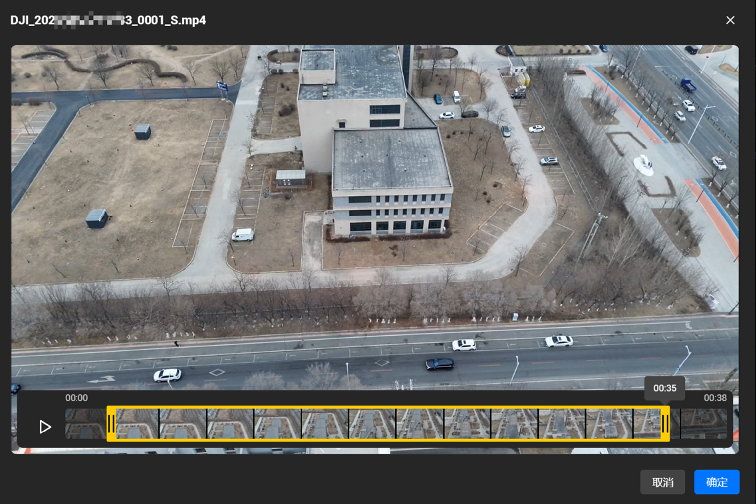
Select one useful segment
Use the video-trim timeline to choose the start and end. DJI documents one trimmed segment per video. Prefer a continuous, stable section that covers the target from changing positions. Avoid treating take-off, abrupt turns and unrelated transit footage as useful just because they increase clip length.
-
Choose Auto or Manual extraction
Auto is DJI's recommended starting method: the manual describes removing blurred frames and retaining clearer ones. Manual extraction uses a user-defined frame interval. Use it for a deliberate comparison when needed; there is no documented universal interval that makes every flight reconstruct well.
-
Inspect the extracted images
Confirm extraction, then review the photos in project management. The documented storage path is
image/keyframes/[video name]/inside the project directory. Check actual sharpness, exposure and viewpoint changes before launching a larger reconstruction. Save the selected segment and extraction settings in the project record. -
Run a representative pilot and examine the reports
Process the relevant reconstruction stages for the intended output. Review aerotriangulation, image positions and the resulting geometry. Record failures and settings. Expand to other segments only after the pilot shows that this source can answer the original question.
Change one meaningful variable at a time when comparing runs: the chosen segment, extraction method or reconstruction setting. Keep the source fixed and name the outputs clearly. Otherwise, a cleaner-looking model may be attributed to the wrong change, and another operator will struggle to reproduce it.
04 — Inspect the frames and the camera geometry
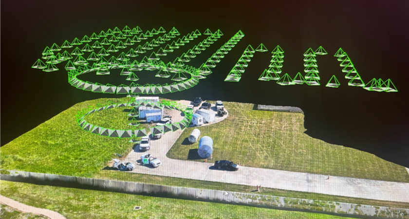
Automatic frame selection reduces manual sorting; it cannot invent viewpoints. A stationary pan can show a wide field of view without providing the positional change needed for robust depth. Similarly, repeated frames taken from almost the same position may add processing work without covering a hidden wall or connecting separate parts of the scene.
Check the surfaces that matter, not just the frame count
Open representative extracted images at a useful inspection scale. Look for motion blur, crushed shadows, washed-out surfaces and abrupt differences in zoom or framing. Then follow the subject through the sequence: does it remain visible across changing camera positions, or disappear behind an obstruction? Are the required sides and ground transitions actually recorded?
Feature-poor snow, water, reflective surfaces and repetitive patterns can make matching difficult. Moving vehicles or vegetation may be inconsistent between frames. DJI's general reconstruction guidance discusses these image-quality and texture issues; it does not provide a video-specific threshold that makes such scenes safe for measurement. A large number of extracted images is not a substitute for connected, useful observations.
Use the AT report as a diagnostic, not an accuracy certificate
DJI's aerotriangulation report guidance identifies calibrated-image count, connected components, reprojection error and georeferencing RMSE among the review parameters. Uncalibrated images or multiple components warrant investigation. A coherent scene should not be silently accepted if the target area sits in a disconnected fragment.
Distinguish internal image fitting from external accuracy. A low reprojection error indicates image observations fit the estimated geometry relatively well; it does not independently prove the model's absolute coordinates or elevations. Likewise, georeferencing RMSE against recorded image positions is not the same as a checkpoint survey outside the reconstruction.
Rolling-shutter optimization is a separate Terra capability. Its announcement alongside video extraction does not establish that it is automatically applied to every extracted frame. Do not describe either feature as a cure for blurred footage, absent GPS, missing coverage or an undocumented camera source.
Keep the original files intact
05 — Troubleshoot the failure you actually have
Use the failed step and error code to choose the next action. Repeatedly changing image intervals will not repair a corrupted file, and a GPU upgrade will not supply missing flight data. The following table paraphrases DJI's current reconstruction exception guidance; it is not a complete list of Terra errors.
Scroll within the table to read the recovery action on a phone.
| Code / stage | First check | Recovery action |
|---|---|---|
| 1031 — file | Zero/unusually small file or unsuccessful playback. | Recover the complete original from the aircraft/SD card; avoid interrupted export, compression and transcoding. Re-import. |
| 1032 — decoding | Play the full recording; look for freezing, artifacts or interruption. | Recover the original without third-party trim/transcode. If decoding still fails, update the GPU driver; escalate with a permitted sample. |
| 1033 — flight metadata | Same-base-name SRT in the same directory as the video. | Recover the matching original video/SRT pair. Do not substitute another flight's data. Files genuinely lacking flight data cannot be used directly. |
| 1034 — GPS | Whether capture had usable GPS, rather than prolonged signal loss. | Recollect in a suitable GPS environment. Re-export alone cannot create missing GPS observations. |
| 1035 — cache | Free space at the actual cache location. | DJI specifies at least 10 GB, recommending 20 GB or more, for this cache error. This is separate from overall workstation/project storage planning. |
| 2001 — aerotriangulation | Texture, exposure, overlap and connections between images. | Review the source and extracted frames. If dataset issues are excluded, collect logs and contact DJI support rather than inventing acquisition metadata. |
For support escalation, collect the installed Terra version, edition, error code, failed stage, extraction settings and the smallest original sample that still demonstrates the problem. Include relevant logs and a short account of what you have already tried. Check organizational permissions before sharing footage of people, sensitive assets or an incident scene.
Preserve the failed project and create a separately named retry. An intact record helps distinguish an export failure from a capture limitation, and prevents a later reviewer from mistaking a manually altered source for the original evidence.
06 — Decide between archived video and planned photos
Use video when existing footage is the available source and a pilot shows useful coverage for the intended decision. Plan a dedicated photo mission when you control acquisition and need repeatable geometry, deliberate surface coverage or a specified measurement deliverable. The distinction is acquisition control, not a claim that one mode wins every reconstruction.
All comparison cells are retained. Scroll within the table on a narrow screen.
| Decision | Existing video frames | Purpose-flown photographs |
|---|---|---|
| Coverage | Constrained by the route, view direction and obstructions already recorded. | Can be planned around the required surfaces and checked before leaving the site. |
| Image selection | Extraction helps find usable observations within the clip. | Capture settings and positions can be selected specifically for reconstruction. |
| Repeatability | An archive may lack consistent routes or complete acquisition records. | A documented mission can support more consistent repeated observations. |
| Measurement use | Must be evaluated against independent checks and the intended use. | Still requires validation; a mapping aircraft or planned route alone does not certify accuracy. |
A hybrid approach can be useful for evaluation, but do not merge unrelated dates or changed scenes without a reasoned reconstruction plan. An archive model may establish what was visible on one date, while a new mission measures current conditions. Those are different records and should remain distinguishable.
If the deliverable is stockpile volume, use the dedicated stockpile measurement workflow to address coverage, base-surface assumptions and validation. Video import is an input capability, not a replacement for that measurement methodology.
07 — Validate the output, restrict its use or re-fly
Define acceptance before inspecting a polished rendering. For visual orientation, the relevant checks may be scene completeness, recognizable features and clearly labelled blind areas. For an engineering or financial measurement, acceptance needs the project's coordinate requirements, independent reference data and an agreed tolerance. A model that passes the first use may fail the second.
DJI's accuracy-check methodology describes comparisons with higher-accuracy, independent sources and RMSE-based assessment. For a consequential deliverable, agree which features or checkpoints will be checked, how their reference values were measured and how errors will be reported. Do not use a point fitted as control as the sole independent test of the resulting model.
Inspect local geometry as well as summary statistics. A wall can be incomplete, a roof edge distorted or a region weakly connected even when the overall model looks plausible. A single known distance is a useful diagnostic but cannot certify every dimension, surface or coordinate in the scene.
Choose the action that matches the limitation
- Original flight data missingRecover the correct recording and companion data. If never captured, recollect; do not fabricate it.
- Required surfaces absent or poorly connectedAcquire the missing views where permitted. More extraction from the same inadequate views does not fill the gap.
- Usable geometry, no independent accuracy evidenceRestrict to a declared visualization use, or obtain the checks needed for measurement approval.
- Checks meet the agreed project requirementsDeliver with validation results, coordinate information, limits and an identified reviewer.
Re-flight should address the failure, not simply repeat the original route. If the issue is missing views, plan additional coverage. If it is motion blur or feature-poor conditions, change the acquisition approach. If the geometry is adequate but reference checks are missing, resolve the validation plan before assuming a new clip will help.
Canadian flight requirements, site access and scene restrictions remain separate from software capability. Processing footage does not authorize another flight or guarantee that a result is acceptable to a regulator, engineer, insurer or court. Obtain the applicable operational permissions and professional review for the project.
08 — Apply it carefully to emergencies and archives
DJI positions video frame extraction for rapid use of video archives, including emergencies where individual photo capture was not practical. The advantage is access to an existing source—not an established processing-time or accuracy guarantee. Run a small feasibility test before promising a complete scene model to another team.
Emergency scene orientation
An illustrative response workflow is to preserve the original recording, build a limited model from qualifying footage and label the visible area and acquisition time. It may help a briefing team understand spatial relationships after initial capture. Keep the original video available so reviewers can inspect objects or motion that a static mesh fails to represent.
Do not replace time-critical observation with a reconstructed scene or describe a rapid model as a certified accident survey. Moving people and vehicles, changed conditions and hidden surfaces limit what the mesh can establish. The receiving team needs to know what was reconstructed, what was not and which decisions remain unsupported.
Historical asset review
For an inspection archive, first ask whether recovering a model would answer a specific question: viewing a recorded facade, orienting a later inspection or reviewing documented site context. If the question instead requires an exact dimension or a change measurement, establish independent validation and comparable dates. Two visually similar models are not automatically a defensible change analysis.
Keep source date, selected segment and exclusions attached to every exported view. These examples are recommended applications to evaluate, not SpeedyDrone field-test results. A failed pilot can still be useful: it identifies whether the archive needs better file retention, a different capture plan or a dedicated future survey.
A reusable project record
09 — Deliver the model with its evidence and limits
A standalone mesh rarely tells the next operator how it was made. Include a short record linking the exported result to its source, processing settings and acceptance decision. The checklist below is a recommended team template, not a DJI-mandated form. Its purpose is to make the work reviewable without relying on the original processor's memory.
Copy these fields into your project record. Scroll within the table on a phone.
| Record field | What to retain | Why it matters |
|---|---|---|
| Source and custody | Original filenames, capture date, aircraft, storage location and matching flight-data files. | Links the model to the recording; distinguishes originals from processing copies. |
| Selection | Start/end time, extraction method and any manual interval. | Allows another operator to reproduce the selected observations. |
| Processing | Terra version/edition, project path, reconstruction settings and output name. | Explains which run produced the deliverable. |
| Quality review | AT report, image connections, missing areas, visible defects and failed/retried steps. | Prevents a visually convincing result from concealing acquisition limitations. |
| Coordinates and checks | Declared coordinate system/units, independent references, errors and agreed acceptance limits. | Separates visualization from an approved measurement use. |
| Delivery and approval | Format, intended viewer, permitted use, exclusions, reviewer and approval date. | Gives the receiving team a clear use boundary and accountable decision. |
DJI documents mesh export choices including OBJ and PLY, with tiled options for other viewers. Choose according to the receiving application and test the actual exported bundle before delivery. Confirm textures, orientation, scale and coordinate interpretation; do not assume one successfully opened preview proves every exported format is usable.
If the next step is model editing, use the Terra-to-Modify cleanup workflow as a separate reference. Cleaning a mesh can improve presentation, but removing an artifact or filling a hole does not create independent evidence of the missing real-world surface. Keep raw and edited results distinguishable.
10 — Match the software and acquisition plan to the job
First establish whether the existing footage is usable. Then decide whether your team needs software access, workstation changes or a new acquisition plan. Buying a higher edition or a different aircraft before identifying the failed gate can leave the original problem unresolved.

DJI Terra Standard
The official feature matrix supports ordinary visible-light mesh and DSM/DOM reconstruction in Standard, alongside video import. Check the exact licence term, activation arrangement, installed version and receiving output requirements before ordering; Gaussian splatting has a different edition requirement.
Review DJI Terra Standard options. For a broader edition decision, see the Standard vs Flagship buying guide and reconcile its guidance with DJI's current matrix.

DJI Matrice 4E
Matrice 4E is a documented video source and a planned-photo mapping option with a 20 MP 4/3 wide camera, mechanical shutter and RTK capability. It is relevant when the job requires deliberate new coverage. Those features do not retroactively validate an archive or eliminate independent checks.
Review DJI Matrice 4E. Define the required deliverable and capture method first; a compatible aircraft is one part of the workflow, not an accuracy certificate.
11 — Frequently asked questions
Can DJI Terra turn any drone video into a 3D model?
No. DJI documents MP4/TS input from named enterprise aircraft and requires GPS metadata. The original recording must be readable and retain usable flight data; a matching SRT is a specific check for missing-metadata error 1033. Compatibility is only the input gate. The extracted frames still need suitable sharpness, texture, overlap and viewpoints for reconstruction. A social-media download, screen recording or third-party export should not be assumed equivalent. Check the current data-import manual and run a representative pilot before committing an archive or promising a deliverable.
Does the video need a matching SRT file?
When Terra reports missing position or orientation metadata under error 1033, DJI instructs users to check for a same-name SRT flight-data file beside the video. Recover the complete original pair from the aircraft or SD card if it is missing, and keep their base filenames and directory aligned. This is a documented recovery step, not proof that any subtitle file makes a clip compatible. Do not use another recording's SRT or fabricate coordinates. If flight data was never captured, file renaming cannot repair the source.
Should I use Auto or Manual frame extraction?
Start with Auto, which DJI recommends and describes as removing blurred frames while keeping clearer ones. Manual extraction uses a frame interval you select. It can support a controlled comparison, but there is no documented universal interval for every speed, altitude or scene. Inspect the resulting images and reconstruction rather than judging only by image count. Additional near-identical frames do not provide a missing viewpoint. Keep the selected segment and settings in the project record so another operator can reproduce the run.
Can I trim or transcode the recording before importing?
Avoid doing so to the original. DJI's decoding and missing-metadata troubleshooting guidance warns against third-party trimming, compression and transcoding because the original video or flight data can be compromised. Preserve the untouched aircraft recording and matching data, then select the useful segment inside Terra. The current manual documents one trimmed segment per video. If a previously edited copy fails, recover the complete original rather than repeatedly converting it. Retain an archived original and clearly named working copies for review and support.
Can extracted video frames be used for a 2D map?
Yes—the current data-import manual explicitly says extracted frames can enter aerotriangulation, 2D, 3D and Gaussian reconstruction. This resolves the narrower wording in the original feature announcement. It does not mean every clip is suitable for an orthomosaic: oblique coverage, hidden ground or weak connections may prevent a useful map. The licence must also support the selected output. Assess coverage, coordinate requirements and any independent accuracy checks for the actual deliverable, rather than treating the availability of a 2D option as automatic acceptance.
Do I need Terra Flagship for a video-derived mesh?
Not solely because the input is video. DJI's current edition matrix lists video import and ordinary visible-light mesh reconstruction in Standard. It separately lists Gaussian splatting for Flagship and Cluster in the detailed comparison. Match the licence to the intended output and any additional workflow requirements, not to the word “video.” Before buying or activating, confirm the exact store SKU, term, authorization arrangement and installed version. A licence's ability to import a file does not establish that every reconstruction feature is included.
Is a GPS-tagged video model survey-grade?
GPS metadata enables the documented workflow; it does not establish model accuracy. Image geometry, source quality, coordinate handling and project validation remain separate questions. For consequential measurements, compare against appropriate higher-accuracy independent references and report the results against agreed project requirements. Internal reprojection or image-position statistics are useful diagnostics, not a substitute for external checkpoints. RTK capability on the aircraft also does not prove that an archived recording meets a given accuracy tolerance. Restrict use to visualization if measurement fitness has not been demonstrated.
Will extracting more frames fix holes or disconnected areas?
Only if the recording contains useful observations that the current selection missed. More frames from the same inadequate position will not reveal an occluded wall, replace lost GPS or add texture to a featureless surface. Review the selected segment, calibrated-image count, camera positions and connected components to identify the cause. A different extraction choice may help selection; missing coverage usually needs new acquisition where permitted. Preserve the failed run and record the reason for a retry so a later operator does not mistake processing changes for new source evidence.
What should accompany the exported model?
Include a source and processing record: original filenames and date, selected segment, extraction settings, Terra version/edition, reconstruction settings and output format. Add the coordinate system and units, quality findings, missing areas and independent validation where required. State the approved use, exclusions and responsible reviewer. Test the exported bundle in the receiving viewer, including textures and scale. Keep raw and edited versions distinguishable. This lets another team understand what the model supports without treating an attractive rendering or cleaned mesh as proof of accuracy.
12 — Primary references and update boundary
This resource uses DJI's current online manual, reviewed October 7, 2026. Software, edition entitlements and source compatibility can change. Check the live documents for your installation; the operator checklist and acceptance framework above are editorial recommendations, not a substitute for a project technical specification.
- Data import — video sources, extraction controls and downstream reconstruction.
- Reconstruction exception guidelines — file, decoding, metadata, GPS and processing errors.
- Software edition comparison and configuration requirements — licence and workstation preflight.
- Aerotriangulation and accuracy-check methodology — diagnostic reports versus independent checks.
- 3D mesh settings and output viewing — exports and review.
- Release notes and July 2026 feature announcement — feature history and original positioning.


