


Enterprise mapping resource · Canada
Use DJI Terra to reconstruct and verify the model, then use DJI Modify to clean a separate, traceable derivative. Preserve the untouched reconstruction, keep linked project paths intact, record every consequential repair, and test the exported files in the client’s actual viewer. A cleaner mesh can be easier to navigate and present. It does not, by itself, make measurements more accurate or turn reconstructed surfaces into surveyed evidence.
This guide covers visible-light 3D mesh cleanup after reconstruction. It is for teams handing models to municipal GIS, construction, asset-management or project-review users. Point-cloud classification and terrain generation are separate workflows, even when the file extension looks familiar.
Technical review: October 7, 2026. Workflow details checked against DJI Modify v1.6 documentation. Interface labels, licensing and available formats can vary with the installed version.
In this resource: jump to a workflow decision
01Before opening DJI Modify: three gates
Start with the client’s decision, not the repair tool. A textured mesh for a stakeholder presentation, a model used to navigate an inspection, and a surface used in an engineering calculation do not have the same acceptance criteria. Write down the intended use, required format, coordinate reference system, units, target software and reviewer before editing.
Evidence gate: is the reconstruction defensible?
Confirm that imagery, project settings, control information, aerotriangulation and reconstruction outputs are available. Resolve unexplained offsets, incomplete coverage and failed project checks in Terra first. If a checkpoint or independent validation is required, retain its result separately from any visual cleanup record. A convincing texture cannot explain a coordinate error.
Coordinate gate: will the handoff stay in the right place?
Document horizontal and vertical references, units and any transformations applied upstream. Modify is not a coordinate-conversion stage. The v1.6 manual excludes mesh inputs with custom coordinate systems or seven-parameter transformations; the product notes also identify custom elevation limitations. Check a proposed coordinate workflow against the current documentation before committing editing time.
Compatibility gate: is this the supported mesh path?
DJI documents Terra v4.0.0 or later for this mesh workflow, with Work with DJI Modify enabled to generate the editable output. The current manual also excludes models reconstructed from photos without image POS data. A generic OBJ or PLY from another application is not proof that all Modify mesh tools will work.
Check the workstation and authentication path as well. DJI documents Windows, an NVIDIA GPU and substantial RAM/VRAM requirements. An offline Terra licence does not establish that Modify can be used offline. Test a representative block on the intended machine before allocating a large editing job.
The controlled path from reconstruction to release
- 1. Validate in TerraResolve source, control and coordinate questions before cosmetic work.
- 2. Preserve the masterKeep an untouched evidence set and stable linked workspace.
- 3. Edit a derivativeChoose repairs by intended use and record the affected areas.
- 4. Test the deliveryRender, export, open in the target viewer and obtain acceptance.
02A controlled Terra-to-Modify handoff
Before creating the linked editing project, preserve the raw imagery, Terra project, reconstruction results and QA evidence under your organization’s backup policy. Keep an untouched deliverable that can be reopened. This independent preservation is different from renaming or copying folders after Modify has established its links.
Generate the right editable output
Enable Work with DJI Modify in the supported Terra reconstruction workflow. The v1.6 manual describes generating a DMEP editable-project file and opening Modify from Terra after reconstruction. Existing compatible Terra projects can generate the required outputs without repeating the entire reconstruction process. Follow the current Terra instructions rather than treating every missing DMEP as a reason to reprocess all source data.
If creating a project manually, check the requested model and aerotriangulation inputs. The manual identifies B3DM, PLY, AT XML and undistorted-image inputs in the mesh project setup. Undistorted imagery matters when projecting texture onto repairs. Verify access to these supporting files on the editing workstation, not just the presence of a model that initially opens.
Protect linked names and paths
Once linked, leave the Terra task name and modelling-result folders in their established locations. DJI warns that moving, copying or renaming those linked results can make files inaccessible. Do not tidy the working directory, rename the Terra task for a client, or delete the source project as a routine disk-cleanup step. The manual warns that deleting the Terra project can also delete its linked Modify project.
Project transfer is not model export. To move an editable job to another workstation, use Modify’s documented Project Export and re-import workflow. Keep the exported/unpacked project in a stable location. Include undistorted imagery when later texture editing requires it. A final OBJ or tiled-model delivery is not a substitute for the editable project’s dependencies.
Record Terra and Modify versions, the active workspace path, backup location and project owner. On a second machine, perform an import-and-open check before the original workspace is retired. If dependencies are missing, stop and restore the documented structure; repeatedly moving folders makes diagnosis harder.
03Build a defect register before batch editing
Review the model in both overview and close-up views. Give each questionable area a block reference, a screenshot and a decision: keep, repair for presentation, or return to reconstruction/capture. Record what the source images show and which intended use is affected. This prevents “select all” from becoming an undocumented editorial decision about the site.
The register below is a planning template. On small screens, scroll horizontally to read all three columns.
| Symptom | First check | Release decision |
|---|---|---|
| Floating fragments | Compare with imagery. Is the fragment noise, or a real disconnected object? | Remove verified artifacts; preserve real structures and record the selection. |
| Vehicle-shaped bumps | Does the client need a cleared presentation surface or the captured site condition? | Flatten only the presentation derivative when removal is justified. |
| Holes or missing walls | Check coverage, occlusion and whether the gap is a real opening. | Disclose a visual patch; return upstream if the missing surface matters to the decision. |
| Distorted texture | Check source-image access and whether the visible feature is evidence. | Repair appearance without inventing asset details, defects or markings. |
| Water bulges or gaps | Check shoreline, nearby structures and the editing/deletion range. | Label a repaired surface as an edited representation, not measured bathymetry. |
| Global offset or block misalignment | Review CRS, control, aerotriangulation and reconstruction. | Return to Terra/source QA. Do not hide alignment problems with surface tools. |
For example, a vehicle can legitimately be absent from a cleaned public presentation while remaining important in the original construction record. Those are different deliverables, not competing versions of the truth. Agree on the distinction with the client before removing it.
04Repair conservatively, one defect type at a time
Use a small, representative area to establish the editing standard. Review the result, agree what must remain visible and then work through the register. Batch repair is useful after the selection rules are understood, not before. Save at deliberate milestones and keep an independent record of consequential edits.
Choose the editing level and blocks deliberately
The v1.6 manual describes high-quality PLY and low-quality B3DM mesh levels. Local flattening, texture repair and hole filling use enabled high-quality blocks; broad floating-part and water work follow the lower-quality path. These are editing representations of the same project, not interchangeable quality labels for every export extension.
Load only the blocks needed for the current repair. If RAM or VRAM runs out, unload high-quality blocks, save explicitly and reopen as needed. Check the current DJI block-splitting guidance before processing another large job. Hiding a block and unloading its high-quality representation are different controls; inspect which blocks are actually included in the operation.
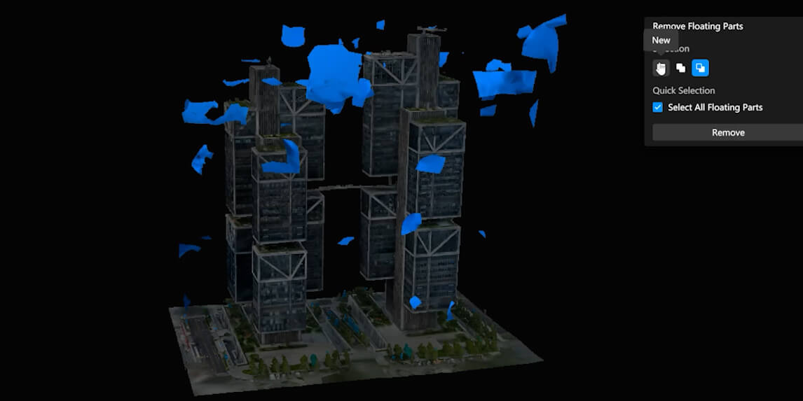
Floating parts: review several views
DJI’s FAQ explains that floating-part removal depends on what is visible in the current view. After one pass, zoom and inspect again as blocks update. Remove known artifacts while deselecting objects that should remain. Pay particular attention to thin structures, isolated assets and site-edge objects that could be mistakenly treated as noise.
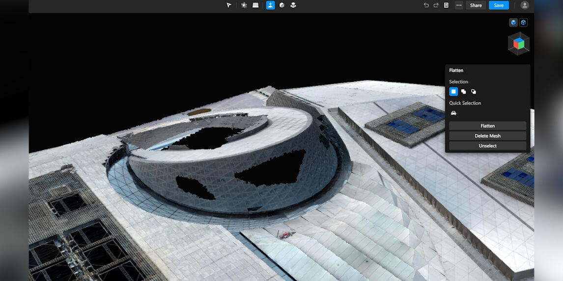
Flattening: select the right surface, not just the vehicle
Use an appropriate near-top-down view for vehicle recognition and inspect the selected boundary manually. Preserve curbs, ramps, steps and nearby structures. The v1.6 manual includes flattening direction and height controls, including custom height. Setting a height still does not verify that it matches the measured ground, preserves the correct slope, or meets an engineering tolerance.
Inspect every block boundary crossed by the repair. A locally convincing surface can leave a seam or height discontinuity at its edge. Compare it with the untouched model and neighbouring geometry, and record any area that is acceptable for presentation but excluded from downstream measurement.
Hole filling: identify the gap before closing it
A mesh opening may be incomplete reconstruction, an actual doorway, an underpass or an occluded surface. Inspect the source evidence before filling it. For a permitted visual patch, check the selected perimeter and resulting surface from multiple angles. Confirm that the repair did not bridge separate objects or cover a real opening.
If the result receives an unsuitable or solid-colour texture, check access to the supporting aerial/undistorted imagery and aerotriangulation files before painting over the symptom. A visually improved patch remains edited geometry. If that wall or surface is central to the client’s task, disclose the gap or return for better source coverage.
Texture and water repairs: review what the tool changes
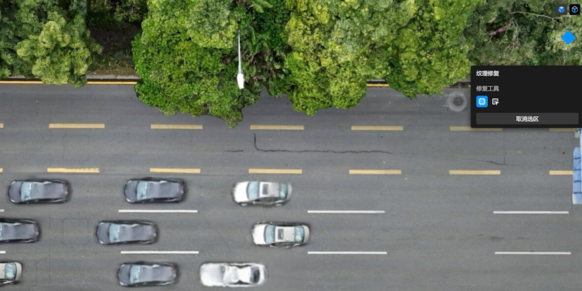
Erase and Clone can improve appearance, but copied pixels are not a new observation. Do not clone a road marking, crack, façade feature or asset label into a location where the source does not show it. Keep evidence-bearing details in the original record and describe presentation edits separately.
For water, review the polygon, height and mesh-deletion range before committing the operation. The manual describes removal of mesh below the water surface and within an adjustable range above it. Inspect bridges, quay edges and nearby assets after rendering. A smooth water plane is not a measurement of the lakebed or proof of a surveyed water level.
05What cleanup can and cannot prove
Cleanup can make a model clearer, easier to navigate and more suitable for a defined presentation. It can also remove or change information. The central release question is therefore not “does it look better?” but “can the recipient distinguish captured evidence from the edited representation?”
Keep the untouched master as the reference for the captured condition. Link each substantive repair to the defect register and identify areas where geometry, texture or an asset’s presence has changed. For decision-critical surfaces, agree whether the original evidence is sufficient, whether an independent check is needed, or whether the area must remain excluded.
Keep the evidence and the edited representation distinguishable
Evidence set: preserve
Source imagery, reconstruction settings, coordinates, control/checkpoint results and untouched output.
Purpose: explain what was captured and how the original model was validated.
Cleaned derivative: document
Removed objects, filled geometry, altered textures, repaired water and simplified export settings.
Purpose: support the agreed presentation or operational use with disclosed limitations.
For Canadian projects requiring professional survey interpretation or sign-off, involve the responsible qualified professional in the acceptance criteria. Software editing alone is not that sign-off. Avoid blanket “survey-grade,” “engineering-ready” or accuracy-improvement claims unless the specific deliverable has supporting validation.
06Render, export and test the client’s actual viewer
Save the editing state explicitly before rendering. The v1.6 manual describes a pre-render history backup, but not an automatic backup of the post-render version. Directly closing or exiting Modify is not a reliable autosave strategy. Name important saved versions and retain an independent backup before irreversible workspace cleanup.
Render synchronizes edits between model levels. Inspect the rendered result again rather than approving only the editing view. Check repaired areas, block seams, textures and objects near selections. If the rendered result differs from the intended repair, resolve that discrepancy before exporting or sharing.
Confirm formats against the installed version
The v1.6 manual lists B3DM, OSGB, PLY, OBJ, S3MB and I3S in its mesh export section. It also documents format-specific merging/simplification controls, with FBX appearing in those controls and in the release notes. The FAQ’s shorter default-format list is not a complete substitute for version-specific documentation. Confirm the exact option in your installed build and test it with the client’s software.
Merging blocks can simplify file management. Reducing triangles and texture can improve loading, but it changes the derivative delivered to the recipient. Retain the full-detail reference and record the simplification settings. Test thin objects, façade detail and texture readability before approving a reduced export; a smaller file is not automatically the better operational model.
Use a short acceptance test
- Open: load the delivered files in the agreed viewer, on a machine outside the editing workspace.
- Completeness: confirm the expected blocks, textures and supporting files are included.
- Position: compare a known reference location and documented CRS/units with the expected project position.
- Edited areas: revisit register entries at overview and close-up scale, including seams.
- Usability: confirm the recipient can navigate and use the model for its stated purpose.
Record viewer/version, export settings, reviewer, date and unresolved limitations. Agree project-specific thresholds rather than inventing a universal loading-time or accuracy target. A successful Export message proves that files were produced, not that the client’s downstream workflow has accepted them.
07Decide whether cloud sharing is allowed in Canada
Separate authentication connectivity from permission to upload a model. The fact that software needs a network licence does not mean the client has authorized cloud distribution of site data. Decide the sharing route before creating a public-facing link.
DJI’s current FAQ states that models uploaded from outside mainland China are stored on US servers and that coordinate information is removed before upload. Under that regional rule, a Canadian upload would use US storage. Coordinate removal does not establish anonymity: geometry, textures, signs and recognizable buildings may still identify the site.
Ask the client’s data owner to approve the destination, recipients, access controls, sharing period and any applicable procurement or cross-border restrictions. Municipal, utility and sensitive-infrastructure projects may have contractual requirements beyond the software’s defaults. This guide does not determine legal compliance for a particular organization.
If cloud sharing is approved, verify the available permissions and expiry options in the current version, test access as the intended recipient and record who owns the link. The manual describes sharing permissions, validity period and cloud capacity controls. A link is a viewing route, not the sole archive, editable project or proof that a file has been accepted.
If upload is not approved, use the agreed local/exported handoff and client-controlled transfer method. Do not upload a confidential sample just to test convenience. The broader municipal GIS workflow resource provides context for downstream data ownership and GIS-ready delivery.
08A client handoff package that survives review
Deliver more than a model and a link. The recipient should know which file represents the untouched reconstruction, which is cleaned, what changed and what has not been checked. The following checklist is a recommended editorial control, not a mandatory DJI packing list.
- Untouched master and evidence locationIdentify the reference output and the retained source/QA record. State who maintains it and how the client can request access, subject to the project’s data rules.
-
Clearly named cleaned derivativeUse a revision and purpose label, such as
site-model-presentation-r02. Keep original and edited deliverables distinguishable; do not silently overwrite the reference. - Format, coordinates and settingsList export format, horizontal/vertical reference, units, software versions and any merging or simplification. Include required companion textures and viewer instructions.
- Edit registerFor each substantive change, record block/location, symptom, action, reason, evidence reference, operator, reviewer and date. Include before/after views where they clarify the decision.
- QA, limitations and exclusionsState what was tested, what remains approximate, which areas were not checked and which uses are excluded. Do not hide incomplete source coverage behind a repaired surface.
- Sharing and acceptance recordRecord the approved transfer route, any cloud use, recipients and access period, plus the client’s viewer test and acceptance outcome.
A small example of a useful edit record
Illustrative example, not a customer case: “Block B07, courtyard vehicle area: vehicle mesh removed from presentation derivative; source condition retained in untouched master. Evidence: capture image reference and before/after views. Boundary/texture checked by reviewer; repaired area excluded from surface measurements. Approval status and date recorded in the project register.”
The valuable part is the decision trail, not the amount of paperwork. If a reviewer later asks why an object disappeared, the team should be able to answer without reconstructing the operator’s memory. Release only when unresolved issues are either corrected or explicitly accepted for the stated use.
09Choose the software purchase path after defining the job
Start with representative source data, the required mesh output, workstation and client handoff. Then confirm the edition, term, activation/network requirements and exact features required. A Terra licence name should not be treated as proof that Modify access is included.
SpeedyDrone’s current DJI Terra collection includes the following two purchase paths. These links identify the live listings; they are not a claim that the editions have identical entitlements or that either includes Modify.

DJI Terra Standard
The current listing provides 1 Year and Permanent options. Confirm the selected term, activation arrangement and required reconstruction/output features before purchase. Its legacy URL still contains “pro-permanent”; the current product name is Standard.
View DJI Terra Standard →
DJI Terra Flagship
The current listing provides Subscription 1 Year and Permanent options. Confirm edition-specific capabilities and deployment terms against your actual job. The listing image does not establish a bundled Modify entitlement.
View DJI Terra Flagship →For Modify licensing or an unclear software configuration, contact SpeedyDrone with the installed versions, source/output type and intended delivery. For a broader acquisition-to-delivery plan, use the Surveying and Mapping Solutions page or the DJI Enterprise hub. Do not buy a new aircraft to solve a post-processing issue until the source of the problem is understood.
10Frequently asked questions
What is the difference between DJI Terra and DJI Modify?
Terra reconstructs mapping and 3D outputs from source data; Modify edits supported mesh or point-cloud results. For the mesh workflow here, resolve source, control and coordinate questions in Terra before cleanup. Use Modify to produce a documented derivative, not to replace the original validation. Keep both the untouched output and the edited version distinguishable. Point-cloud classification and terrain processing have their own documented steps and should not be inferred from the mesh repair tools.
Can DJI Modify edit a visible-light model from third-party software?
DJI’s documented mesh workflow uses models reconstructed in Terra v4.0.0 or later. A third-party OBJ or PLY is not evidence of supported mesh-tool behaviour simply because the extension is familiar. Check the current manual, required editable-project inputs and coordinate restrictions before committing time. Do not generalize this mesh answer to every point-cloud import case, which DJI documents separately. If the source application is different, confirm the supported transfer route rather than assuming format compatibility guarantees tool compatibility.
Can I move or rename the DJI Terra result folder after creating a Modify project?
Keep the linked Terra task name and modelling-result paths stable. DJI warns that moving, copying or renaming linked results can make the model or supporting files inaccessible. This does not mean supported project migration is impossible: the current manual documents Project Export and re-import for transfer to another workstation. Preserve an independent backup before migration, include required supporting imagery and test the imported project. Do not delete the Terra source project as routine cleanup; its linked Modify project can also be deleted.
Does cleaning a model in DJI Modify improve survey accuracy?
Not by itself. Removing objects, filling gaps, flattening a surface or editing textures can improve presentation while changing the derivative’s geometry or appearance. The v1.6 height controls do not prove that a chosen height is the correct measured ground. Accuracy remains a question of source capture, control, reconstruction and appropriate validation. Preserve that evidence, document edited areas and agree any measurement exclusions. Where professional interpretation or sign-off is required, a visually cleaned model is not a substitute for it.
Which 3D model formats can DJI Modify export?
The v1.6 manual’s mesh export section lists B3DM, OSGB, PLY, OBJ, S3MB and I3S, and references FBX in format-specific merging/simplification controls. Older FAQ lists are shorter, so confirm the exact options in the installed build rather than assuming every version behaves identically. Agree a format with the client, include its required supporting files and open the delivered export in the target viewer. Point-cloud formats and editable Project Export are separate from this mesh-delivery list.
Does DJI Modify change a model’s coordinate system?
DJI documents preservation of the imported model’s coordinate system on mesh export; Modify should not be treated as a coordinate-conversion step. Its current mesh documentation also identifies restrictions for custom coordinate systems and seven-parameter transformations. Confirm the supported upstream coordinate workflow before editing. Record horizontal and vertical references plus units, then check the exported position in the client’s software. Selecting a display unit or obtaining a successful export message does not replace that downstream coordinate and unit check.
Where is a DJI Modify cloud-shared model stored for a Canadian project?
DJI’s current FAQ says uploads from countries and regions outside mainland China are stored on US servers. Under that published regional rule, a Canadian upload would use US storage. Confirm the current sharing terms and the client’s permission before uploading, particularly where procurement, confidentiality or cross-border requirements apply. Authentication connectivity is not permission to distribute site data. If the client does not approve that route, provide the agreed exported files through an authorized transfer method and retain a separate archive.
Does removing coordinates before cloud upload make a model anonymous?
No such conclusion should be assumed. DJI says coordinate information is removed before upload, but recognizable geometry, texture, signage and surrounding assets can still reveal the location or subject. Review the content as well as the metadata, obtain approval from the data owner and use only the permitted recipients and access period. A shared viewing link is not automatically a public-release approval. When the site cannot be shared under the available controls, use a client-approved local or controlled transfer route instead.
11Official sources and version notes
Checked October 7, 2026. Product behaviour is based on DJI documentation, not hands-on testing by SpeedyDrone. The defect register, evidence separation and acceptance checklist are recommendations developed for this guide.
- DJI Modify Downloads: current software, manual and release notes.
- DJI Modify User Manual v1.6: supported input, project transfer, mesh editing, save/history, render/export and sharing.
- DJI Modify v1.6 release notes: version-specific mesh merging and simplification.
- DJI Modify FAQ: linked-path warnings, floating-part behaviour and regional cloud-storage statements.
- DJI Modify overview and DJI Terra FAQ: ecosystem context and reconstruction questions.
Where an older FAQ summary differs from current version documentation, confirm the installed version and task-specific controls before proceeding. No software licence, cloud-service term or client acceptance requirement is established by this article alone.


