


Sensor fusion for agricultural operations
Three ways to read the field.
What LiDAR, millimetre-wave radar and Penta-Vision contribute—and which obstacles still remain the operator's responsibility.
Quick answer: what is DJI Agras T100 Safety System 3.0?
Safety System 3.0 combines LiDAR, multiple millimetre-wave radar units and a five-camera vision architecture so the Agras T100 can build a more complete picture of terrain and obstacles than any one sensing method could provide.
The value is sensor fusion, not a collision guarantee. LiDAR contributes dense 3D structure, radar provides multi-directional ranging that is useful across difficult agricultural conditions, and vision adds close-range visual context. DJI still requires the operator to monitor the environment, mark linear obstacles such as wires and guy wires, and manually manage moving hazards.
The system is most relevant when an operation combines large payloads with field edges, poles, trees, trellis structures or uneven terrain. It is assistance for a trained operator and a properly planned route—not permission to fly closer to hazards.
| Sensing layer | Primary contribution | What that can mean on a farm | Important boundary |
|---|---|---|---|
| LiDAR | Dense 3D point data, spatial extraction, mapping and recognition support | More structural context around trees, poles, towers, field edges and some linear obstacles | Improved wire recognition does not replace manual wire marking |
| Millimetre-wave radar | Multi-directional distance and obstacle sensing | A robust ranging layer through changing light and agricultural moisture conditions | Overall performance still varies with rain, fog, target material, position and shape |
| Penta-Vision | Close-range visual context plus operator-facing views and obstacle cues | Takeoff/landing awareness and visual confirmation of nearby poles or vehicles | Vision needs adequate light and discernible surroundings |
Why does the T100 use three different sensing technologies?
A farm is not a controlled test corridor. A dark tree line, fine wire, wet canopy and broad building wall do not present the same target. One sensor may provide excellent depth but less useful appearance information; another may keep ranging when lighting changes but give a coarser description of an object's shape.
DJI describes LiDAR, radar and vision as technologies with different strengths. Their combined purpose is redundancy: overlapping evidence gives the flight system and operator more context than a single stream alone. That does not mean every layer sees every hazard, or that one layer can always rescue another.
LiDAR
Builds a high-density 3D point picture that helps describe where terrain and objects sit in space.
Radar
Measures in multiple directions and gives the system another ranging channel across varied farm environments.
Vision
Adds visual detail at close range and gives the operator clearer views of the surroundings and marked hazards.
What does LiDAR do on the Agras T100?
LiDAR measures the environment with laser returns and organizes those measurements into a point cloud. On the T100, DJI says the higher-density point cloud improves recognition of objects such as wires, poles, high-voltage towers and trees. The live laser point cloud also gives the operator another way to understand the space around the aircraft.
That matters because agriculture contains structures that a simple “obstacle ahead” warning does not fully describe. In an orchard, trunks, branches and an irregular canopy occupy different depths. Along a field edge, a pole, guy wire and tree line can overlap visually. On uneven ground, 3D extraction helps the system interpret terrain and preserve operating geometry.
DJI also connects the LiDAR layer with aerial surveying, semantic recognition, positioning and 3D mapping. Those functions help turn obstacle sensing into route context rather than treating every detection as an isolated event.
Wire boundary: more point density can improve wire recognition, but DJI still instructs operators to manually mark linear obstacles—including wires and guy wires—before operation. Never plan a route on the assumption that LiDAR will find every line.
Why does the T100 need radar if it already has LiDAR?
Radar gives the aircraft an independent way to measure distance and direction. DJI identifies millimetre-wave radar as a stable sensing method across agricultural environments and highlights its utility across day, night, fog and water vapour. Multiple radar sets provide multi-directional coverage instead of depending on one forward-facing channel.
The practical answer is not that radar is “better” than LiDAR. It is that the two respond differently to environmental conditions and target characteristics. Radar adds resilience to the sensing stack; LiDAR adds dense spatial structure; vision adds visual detail. The system is stronger because those contributions overlap.
There are still limits. DJI's published performance note says lighting, rain, fog, obstacle material, position and shape can affect obstacle avoidance. The T100 manual also describes radar limitations around some inclined lines, tilted poles, very narrow or complex structures and objects that fall outside the sensor's effective field.
What is the Penta-Vision system?
“Penta” means five within the overall vision architecture: DJI lists a quad-vision system with 360° horizontal and 180° vertical coverage, plus an FPV camera with a stated field of view of approximately ±86° horizontally and 108° vertically.
Penta-Vision supplements LiDAR and radar with visible scene context. DJI says it can help inspect the takeoff and landing surroundings, mark obstacles such as poles and vehicles in the camera view, and automatically show a relevant view when the aircraft encounters an obstacle. That helps the pilot see what the sensor warning relates to instead of reacting to a distance value alone.
It is still a vision system. Low texture, strong reflections, transparent surfaces, water, rapidly changing light, darkness or extreme brightness can reduce visual performance. A clear screen image is not proof that every hazard is sensed.

How do LiDAR, radar and vision work together?
Think of the process as a chain. The sensing layers observe different properties; the system combines the data into a usable model; the flight controller and operator then use that model to slow, stop, reroute or take manual action. A weakness at the first step cannot be solved by treating the final action as guaranteed.
Sensor fusion is especially useful when the route repeats. A first pass can reveal a field-edge object that was not in the original map. The system can then connect the detection with a location and future path decision, while the operator verifies whether the route remains appropriate.

What happens when the T100 finds an unmapped obstacle?
DJI says the T100 can recognize and remember an unmarked obstacle encountered during an operation. The operator can save its location with one action so a later route can plan around it. Even if the location is not saved, DJI says the aircraft can use the prior encounter to anticipate the obstacle when it passes the area again.
A typical example is a utility pole at the edge of a field: the first pass detects it, the operator confirms and records the position, and later route planning builds in the bypass. The useful leap is from momentary braking to repeatable route awareness.
Obstacle memory is only as useful as the operating context. Temporary machinery moves. A new guy wire can be installed. Trees grow and crews change field access. Re-survey the site and verify saved obstacles rather than treating an old route as permanently safe.
Can the Agras T100 detect wires and power lines?
The T100's LiDAR can improve recognition of wires and DJI specifically identifies wires, poles and high-voltage towers as targets that benefit from denser point data. That is not the same as guaranteed wire avoidance.
DJI's current specifications direct operators to mark linear obstacles such as wires and guy wires manually. The user manual also cautions that inclined lines, inclined power lines, narrow or complex tower structures and some pole-shaped objects can fall outside effective avoidance conditions.
The correct workflow is to walk or survey the site, mark known lines and anchors, define conservative route boundaries and keep an observer-focused watch where appropriate. Fine wire against open sky, branches or a reflective background is a poor place to test the system's limits.
Can the T100 avoid moving people, vehicles or animals?
No operator should rely on Safety System 3.0 to actively avoid a moving hazard. DJI states that, because of system limitations, the aircraft cannot actively avoid moving objects. That includes a person entering the work area, a truck crossing a field access road, livestock, wildlife, another drone or a manned aircraft.
Secure the operating area, brief the ground team, establish communications and stop or reposition the aircraft when a moving conflict appears. The manual explicitly places responsibility for other aerial traffic on the operator, including the need to monitor and manually descend or ascend as appropriate.
Safety System 3.0 range, speed and safe distance
The current published figures describe an operating envelope, not promises for every target. DJI lists the following limits for applicable conditions:
“Up to 60 metres” is not a guaranteed detection distance for wire. The figures depend on the obstacle, route and environment. Use the current manual, app limits and site risk controls; slow down and increase separation when terrain, weather or obstacle geometry becomes less favourable.
DJI notes that performance is affected by lighting, rain, fog, obstacle material, location and shape. The aircraft automatically brakes only within the published obstacle-avoidance performance boundaries; outside them, the operator must brake or avoid manually.
How Safety System 3.0 helps in real farm operations
Hardware specifications matter only when they change the operating decision. These examples show where each sensing layer may contribute—and where planning remains decisive.
Open fields
Field edges can contain poles, tree lines, parked machinery and access-road traffic. Long sight lines help, but they can also encourage excessive speed. Use mapped boundaries and saved obstacle positions; treat every moving vehicle as a manual conflict.
Orchards
LiDAR's 3D structure is useful around trunks, branches and irregular canopy, while radar and vision add independent range and scene information. Maintain conservative separation: thin branches, spray droplets, dark foliage and uneven light remain challenging.
Vineyards and trellis
Posts and end anchors provide larger structural targets, but trellis wires are fine linear obstacles. Better recognition is valuable; a pre-flight survey, explicit wire marking and a route that does not depend on last-second braking are more important.
Slopes and uneven terrain
3D terrain extraction and multi-directional sensing support terrain following and stable operating geometry. The manual still calls for lower speeds on slopes and warns that obstacle performance varies with attitude and geometry.
Fog, rain and water vapour
Radar adds a useful ranging layer when moisture or visibility makes optical context less reliable. DJI nevertheless lists rain and fog among the factors that can affect overall avoidance performance. “Radar present” is not an all-weather approval.
Night and low light
Radar does not depend on scene illumination in the same way as a camera, which is why it provides important redundancy. The published operating environment still calls for adequate light and discernible surroundings, and the vision system has dark-scene limitations.
For orchard route planning, coverage and drift-control context beyond obstacle sensing, use SpeedyDrone's orchard and vineyard spraying guide.
How is this different from the Agras T50 safety system?
The Agras T50 uses active phased-array radars and a binocular vision system. The T100 moves to the LiDAR, millimetre-wave radar and Penta-Vision architecture described here. The practical upgrade is not simply a longer feature list: T100 adds dense laser point data, expands operator-facing visual context and integrates the sensing layers with obstacle memory and newer route workflows.
That does not make the T100 the automatic choice for every farm. Payload, throughput, charging logistics, regulatory category, site complexity and crew readiness matter together. Use the separate T50 vs T70P vs T100 comparison for the whole-farm buying decision.
What Safety System 3.0 cannot guarantee
It cannot see outside its effective range
Sensor fields have blind areas and performance envelopes. An obstacle outside them may not be detected in time.
It cannot make every wire safe
DJI calls for manual marking of wires and guy wires. Inclined or fine linear targets remain a specific risk.
It cannot actively avoid moving objects
People, vehicles, animals and aircraft require a secured worksite, active monitoring and manual intervention.
It cannot cancel environmental limits
Lighting, rain, fog, reflective or transparent surfaces, low texture, target material, geometry and contamination can affect sensing.
It cannot replace route planning or pilot control
Manual mode does not automatically bypass obstacles. The pilot must remain ready to brake, stop the job or choose another route.
Does Safety System 3.0 change Canadian SFOC requirements?
No. Sensor capability does not change an aircraft's regulatory category or remove the operator's responsibility. The T100's currently published maximum takeoff weight is above 150 kg in spraying configuration, placing it in Transport Canada's large-drone/special-operation path. Operations over 150 kg require an SFOC-RPAS.
Safety technology can support the risk case; it is not the authorization. The operator must still address the approved operation, site assessment, crew procedures and applicable pesticide requirements. Use only products and application methods permitted by the current label and jurisdiction.
For a broader equipment and compliance decision, see SpeedyDrone's Canadian agricultural drone business guide.
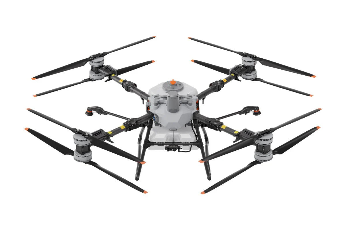
DJI Agras T100 Safety System 3.0 FAQ
What does LiDAR do on the Agras T100?
It creates dense 3D point data that helps the system extract spatial structure and improve recognition of targets such as trees, poles, towers and some wires. It also supports mapping and operator-facing laser point-cloud context.
Why does the T100 use radar if it already has LiDAR?
Radar supplies an independent, multi-directional ranging layer that responds differently to lighting, moisture and target characteristics. Combining radar with LiDAR and vision provides redundancy; it does not make sensing infallible.
What is Penta-Vision?
It is the T100's five-camera vision architecture: a quad-vision system with 360° horizontal and 180° vertical coverage plus an FPV camera. It adds close-range visual context, takeoff/landing awareness and operator-facing obstacle cues.
Can the Agras T100 automatically avoid wires?
Do not assume so. LiDAR improves wire recognition, but DJI instructs operators to manually mark linear obstacles such as wires and guy wires. Route planning must not depend on automatic wire avoidance.
Can the T100 avoid moving people, vehicles or animals?
DJI states that the aircraft cannot actively avoid moving objects because of system limitations. Secure the work area and intervene manually when people, vehicles, animals or other aircraft create a conflict.
How far can the T100 detect obstacles?
DJI publishes a measurement range of up to 60 metres under applicable conditions. Actual performance depends on the obstacle and environment, including material, shape, position, lighting, rain and fog.
Does Safety System 3.0 work at night, in fog or in rain?
Radar provides useful redundancy across changing light, fog and water vapour, but DJI still says the operating environment needs adequate light and discernible surroundings and that rain and fog can affect overall obstacle-avoidance performance.
What happens after the T100 finds an unmapped obstacle?
The aircraft can recognize and remember the obstacle. The operator can save its position so later routes plan a bypass, and DJI says the system can use prior obstacle memory on a future pass even when it was not saved.
Does Safety System 3.0 remove the need for an SFOC in Canada?
No. Safety sensing does not change the T100's large-drone category or replace regulatory authorization, operator responsibility, site risk controls or pesticide-label requirements.
Primary sources and related SpeedyDrone guidance
DJI technical sources
DJI Agras T100 specifications, DJI Agras T100 FAQ, and the current T100 manuals and downloads.
Canadian regulatory sources
Transport Canada operation categories, SFOC-RPAS permission guidance, and Health Canada RPAS pesticide guidance.
SpeedyDrone planning resources
Review the agricultural drone solutions hub, the exact T100 package, and the T100 ROI guide.
Plan a T100 deployment around your real hazards
Share your acreage, crop, terrain, wire and trellis exposure, crew model and charging plan. SpeedyDrone can help you review whether the T100 package and its safety architecture fit the operation you actually intend to run.
Request a T100 safety & deployment reviewCurrent product configuration and availability must be confirmed. A fit review is not regulatory approval or operating authorization.


